In 1997, Phawngpui National Park was notified as a National Park vide notification No.B.12011/5/91-FST of 22.07.1997, covering an area of 50 sq. km, including the entire Phawngpui Mountain along with cliffs and patches of natural grasslands on the tableland near Far Pak. The park is located in the Lawngtlai district under the Lai Autonomous District Council of the Indian state of Mizoram, towards the southeast bordering Myanmar. It derived its name from the Phawngpui Mountain.
The name Phawngpui comes from the local Lai language where “phong” means “meadow” and “pui” means “great,” aptly captures the landscape with expansive grassy glades stretching across the ridges. Another interpretation of Phawngpui comes from the local (Lai-Pawi) dialect, signifying ‘Place of bamboo grass,’ as a large area of the park is covered with bamboo grass.
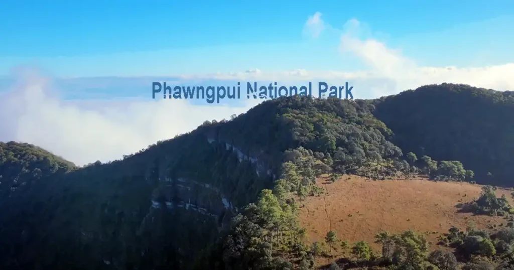
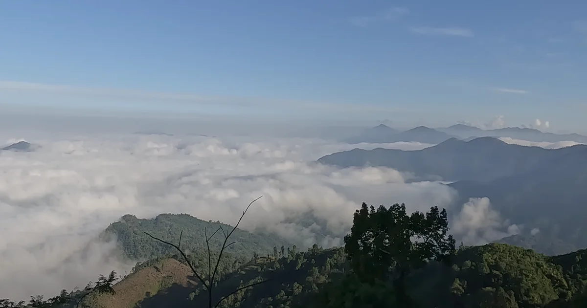
This park is also called Phawngpui Blue Mountain National Park as the mountainous region of Phawngpui is often covered by a thin layer of clouds which makes it blue in appearance from a distance.
The Phawngpui National Park is famous for having the highest point of Phawngpui Peak (2,157 m) in Mizoram.
Phawngpui National Park Boundary
Most of the Phawngpui National Park is covered with different types of forests including Sub-tropical Broadleaf and Tropical Evergreen. There are cliffs and natural grasslands near Far Pak on the tableland. The park is an isolated refuge for wildlife and is surrounded by villages on all sides. The fringe villages are Sentetfiang, Vawmbuk, Sangau, Thaltlang, Cheural, Siachangkawn and Archhuang. The Kolodyne River flows along the eastern boundary of the park is also marking the international border with Myanmar. Beyond the river to the east are the Chin Hills of Myanmar.
The administration of the park is under the Chhimtuipui Wildlife Division, established in 2003 to look after two Protected Areas: Phawngpui National Park and Ngengpui Wildlife Sanctuary within the jurisdiction of the Lai Autonomous District Council in Mizoram. The Deputy Conservator of Forests (DCF), Lawngtlai and the Range Officer is the In-charge of the park.
The Phawngpui National Park is approximately 160 km northeast of Lawngtlai Town (the district headquarters) and about 290 km south of Aizawl, the capital city of Mizoram. It is 12 km from Sangau, another base from where one can trek up Phawngpui mountain.
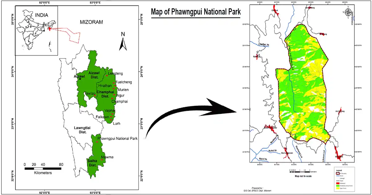 Map of Phawngpui National Park
Phawngpui National Park Geography
The geography of Phawngpui National Park is characterized by the mountainous terrain of Phawngpui, often veiled in a thin layer of clouds getting its name ‘Blue Mountain.’ This distinctive feature gives the mountain a blue appearance when viewed from a distance. The temperature in this region remains mild throughout the year ranging from 11-29 °C, accompanied by an average annual rainfall of 3,000 cm.
The altitude of Phawngpui National Park ranges from 1400m to 2157m with the highest peak and also the highest point in Mizoram measuring 2157 m above mean sea level. It overlooks the landscape and the major river Chhimtuipui flowing towards Myanmar. The edges of the mountains are sharp precipices and very steep slopes. Notably, the western side features a beautiful cliff with a semi-circular shape known as Thlazuang Khâm exhibiting a blunt and deep fall.
The mountain ridge extends in a north-south direction covering approximately 10 km. The closest human settlement to this captivating geography is Thaltlang village, situated at the base and periphery of the park.
The geographical location of Phawngpui National Park is defined by coordinates 22o 36’ 45” – 22o 41’ 56”N and 93o 01’ 08” – 93o 04’ 13” E.
Phawngpui National Park location Google Map
Phawngpui National Park Flora, Fauna and Avifauna
1. Flora
The large area of Phawngpui National Park is covered with bamboo grass named Eulalia trispicata. The natural habitat of various grass covers the landscape and steep slopes are adorned with orchids and rhododendrons along with bamboo patches. The forest type in this area is “Tropical Evergreen Forest” and “Subtropical Montane,” with flora such as Rhododendron species – the red flower (Rhododendron arboreum) and the white flowers (Rhododendron veitchianum, Rhododendron kingianum, Rhododendron parryae, Rhododendron inaequale). Other species include Quercus, Bauhinia variegata, Pinus kesiya, etc. A variety of Orchids are also found in the area. The Daphnia flower, solitary flora blossoms, theopathic basils, oak and rare bamboo groves can be found within Phawngpui National Park.
2. Fauna
Even though it is small in size, the Phawngpui National Park has almost all the mammals found in the forests of Mizoram. The significant wildlife present in the park includes the Golden cat, Leopard cat, Jungle cat, Malayan sun bear, Stump-tailed macaque, Barking deer, Himalayan black bear, Tiger, Goral, Hoolock gibbon, Common langur, Clouded leopard, Marble cat, Slow loris, Sambar, Indian bison, Leopard, Serow, Binturong, etc.
Among the lesser carnivores are the Common palm civet, Small and Large-toothed ferret badger, Yellow-bellied weasel, Yellow-throated marten, Spotted linsang, Hog badger, both the Small and Large Indian civet, etc. Limited information is available regarding reptiles, amphibians, fish and invertebrates.
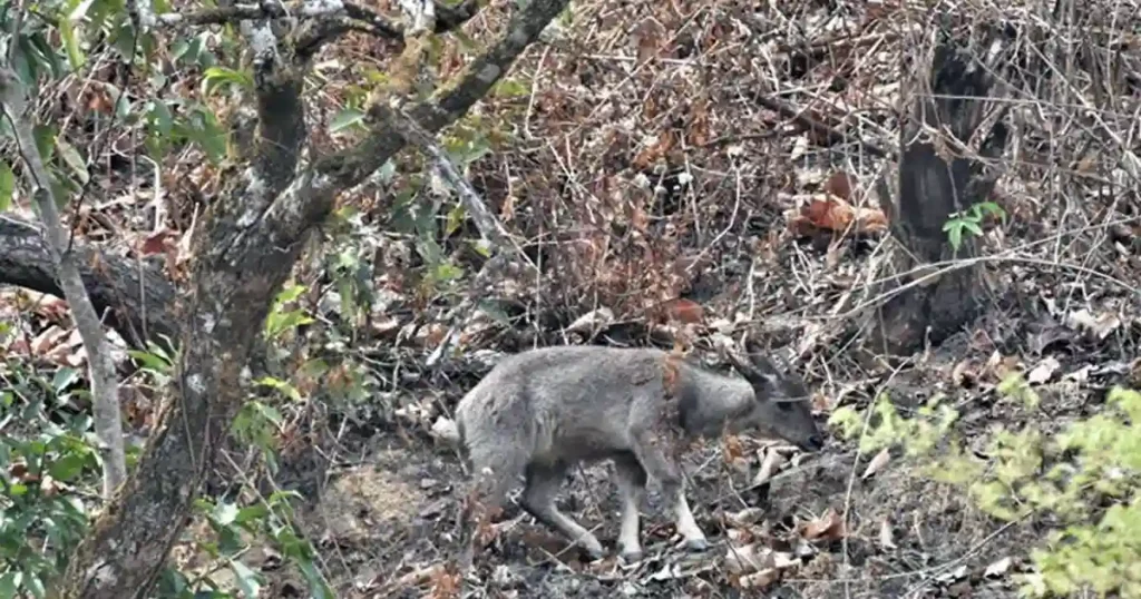 Phawngpui National Park photos : Goral
3. Avifauna
Though the Phawngpui National Park is a small protected area, it is very rich in bird life. The important birds found in the park are rare and endangered Blyth’s tragopan, Wreathed hornbill, Mrs. Hume’s pheasant, Pompadour green pigeon, Grey sibia, Indian pied hornbill, Pintailed green pigeon, Firetailed sunbird, Great hornbill, Kalij pheasant, White-cheeked partridge, Mountain imperial pigeon, Barred buttonquail, Wedge-tailed green pigeon, Speckled wood pigeon etc. has been reported.
Common wood peckers found in the park are Great slaty woodpecker, Golden-backed woodpecker, Greater yellow-naped woodpecker, Crested honey buzzard, Spot-bellied eagle owl, Red-headed trogon, Besra (Mute), Peregrine falcon, Indian roller, Brown wood owl, Crested serpent eagle and Oriental hobby are also found.
The Phawngpui National Park is one of the Important Bird Areas (IBAs) supporting several threatened species such as Mrs. Hume’s Pheasant (Syrmaticus humiae) with a Vulnerable status (BirdLife International, 2001) and Blyth’s Tragopan (Tragopan blythii) also listed as Vulnerable (BirdLife International, 2001). The presence of the globally threatened Dark-rumped Swift (Apus acuticauda) – Khasi Hill Swift enhances its significance in the conservation of this vulnerable species.
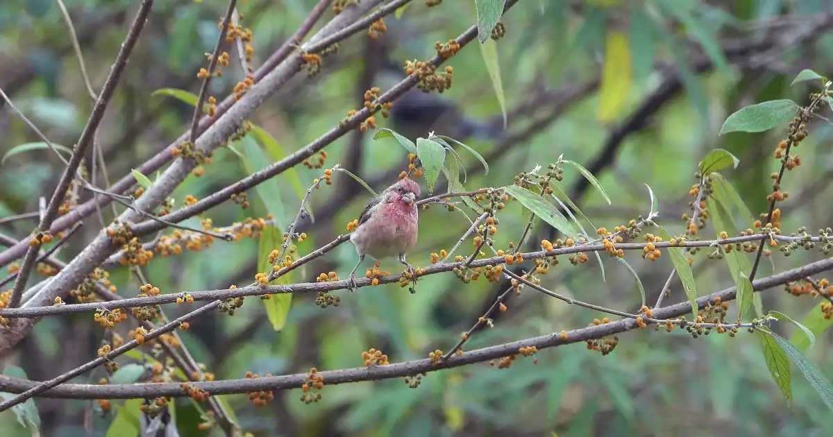 Phawngpui National Park photos : Birds
What you’ll see at Phawngpui National Park
Some of the beautiful sites in Phawngpui National Park are –
a) Far Pak (The great meadow)
Far Pak known as The Great Meadow is a verdant grassland that transforms into a golden-brown expanse during the dry season. The sporadic growth of rhododendrons and pine enhances the natural beauty of this 20-hectare grassland at an altitude of about 2000 meters above sea level. There is a Forest Rest House at Far Pak which can accommodate 10 to 15 people at a time.
There is one captivating story linked to Far Pak and Sangau in the realm near Phawngpui Tlang (Blue Mountain), the highest peak in Mizoram.
“Once upon a time near the Blue Mountain, there were two kings – Sangau, the Ghost King and another in Cheriang. The Ghost King had a son and the King of Cherian had a lovely daughter. The two kings arranged a marriage between their children. The wedding included special gifts: a Pine Tree from the bride’s home and a pair of Hollock Gibbons from the Ghost King to Cherian’s forests. The place where the lone pine stood is now called Farpak and it has grown many more. However, the Hollocks from Sangau, a special gift, sadly did not breed in Cheriang’s forests.”
 Phawngpui National Park photos : Far Pak
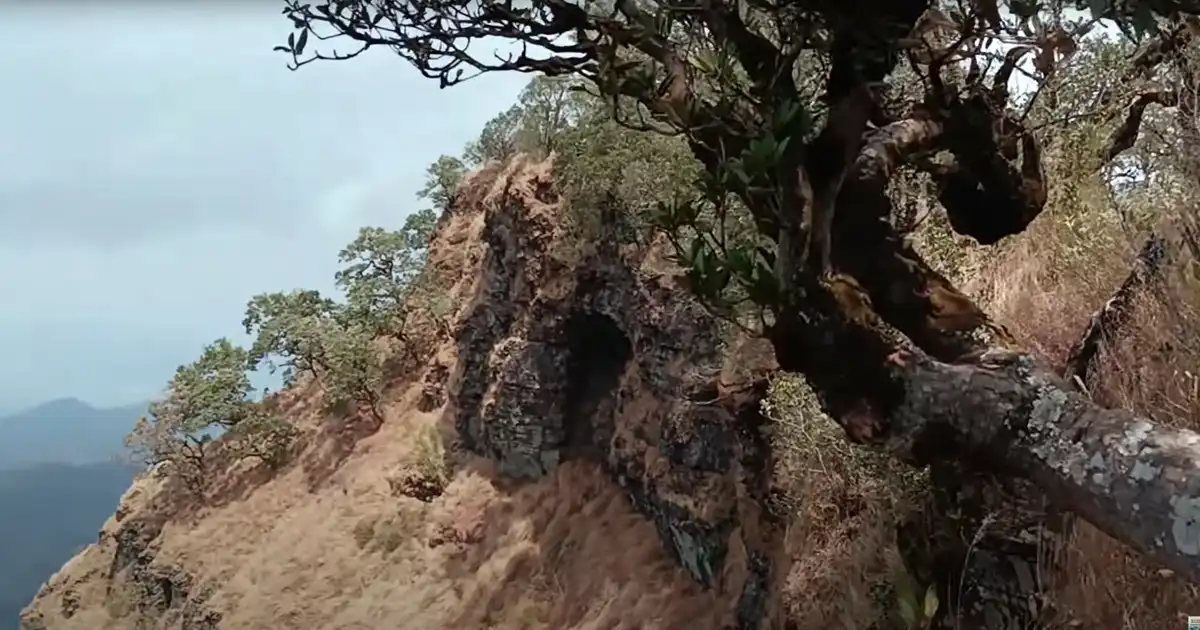
b) Thlazuang Kham
A great vertical cliff known as ‘Thlazuang Kham,’ lies to the west of Far Pak within Phawngpui National Park. It is an extremely steep yet beautiful cliff.
c) The Phawngpui Peak
The Phawngpui peak is the highest point not only in Phawngpui National Park but also in the state reaching an elevation of 2157 meters above mean sea level. Trekking along the trail to the peak takes approximately 2 hours from Far Park guest house and it is approximately 7 km.
When you reach a ridge at this location, there is a viewpoint where you can see two distinct villages. Both villages are situated on the mountain peak along the ridge with one village in Mizoram, India and the other village on the opposite side of the valley in Myanmar. Once again, this area is very close to a new international border.
You can see the clouds over here; this is what adds more to the experience. The clouds are actually passing through as you stand on the ridge. There is a valley down below which is approximately 2,000 to 3,000 feet in depth.
 Phawngpui National Park photos : Phawngpui Peak viewpoint
d) Tialpari Puk
This rock cave is an exciting spot for adventurers to explore. It is located in the southeastern part of Phawngpui Mountain and lies to the south of Lungpher village. Tialpari Puk got its name from a brave woman named Ṭialpari. This small and cozy cave on a rocky area is associated with a touching story of Ṭialpari.
Ṭialpari, the daughter of the chief of Cheural village sought refuge here when her parents tried to arrange a marriage with a chief from a distant village. During her time in hiding, some search parties sent by her father found her. But instead of revealing her location, they secretly provided her with food as they knew she was in love with a brave warrior named Dopawrha who was away at that time.
Legend has it that a tiger would come to keep her company at night and she would cuddle up against it for warmth. After many days, Dopawrha returned to take her away and they got married. Dopawrha later became the chief of a village called Mampui and the couple lived happily ever after.
e) Rhododendrons
The blooming of rhododendrons is a spectacular sight at Phawngpui National Park especially around Far Pak along the route to the peak. These beautiful flowers showcase a burst of red hues from February to March and a display of white blossoms from April to May. This unique floral phenomenon is not commonly found in other parts of the state.
Best Time to Visit Phawngpui National Park
The Government of Mizoram permits eco-friendly visits to Phawngpui National Park also known as Phawngpui Blue Mountain National Park exclusively during the dry season. The permits are available for six months from November to the end of April. The remaining part of the year is dedicated to natural development and rejuvenation. The best time to visit the park is during February and March when you can experience the flamboyant beauty of the exceptional plants and animals. Camping is not allowed inside the park as is the case with most national parks.
1. Entry Fee of Phawngpui National Park
The park is open daily from 6:00 am to 4:00 pm and there is a minimal entry fee to access the national park. It is closed on Sundays.
- Adult-Rs.10.00 per person
- Student–Rs.05.00 per person
- Children below 12years- free
- Foreinger-Rs.20.00 per person
- Camera-Rs.100.00 per unit for Indian
- Camera -Rs.200.00 per unit for Foreigner
- Camera -Rs.200.00 for shooting of documentary film
- Light Vehicle-Rs.200.00 for unit entry
- Two-Wheeler-Rs.50.00 for unit entry
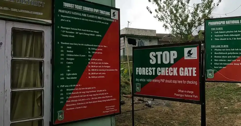 Phawngpui National Park photos : Entry Fee
2. How to Reach?
By air:
The Aizawl airport at Lengpui is the nearest airport to Phawngpui National Park, which is approximately 299 KM away via NH2. It is the only airport in the state and is well-connected to other cities such as Kolkata, Guwahati and Imphal. There is a regular helicopter service twice a week from Lawngtlai to Aizawl. From the airport you can hire a car or take a bus to reach the park.
By Rail:
The nearest railway station is Silchar in Assam which is approximately an 18-hour drive from Lawngtlai. Maxi cabs are available for travel from Lawngtlai to Aizawl and from Aizawl to Silchar. This transportation service operates daily except on Sundays.
By Road:
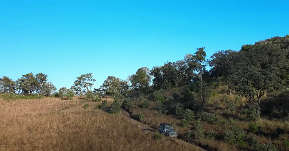
Lawngtlai can be reached in approximately 10-12 hours from Aizawl. It is one of the farthest districts located in the southern part of Mizoram. Sumo services are always available for the journey to Phawngpui National Park allowing you to witness the beauty of Mizoram, its greenery and culture along the way. Phawngpui National Park is approximately 160 km northeast of Lawngtlai Bus stop.
3. Where to Stay?
There is a Forest Rest House at Far Pak that can accommodate 10 to 15 people at a time. Sangau, a village near the Phawngpui National Park is approximately 230 km from Aizawl through Hnahthial and about 160 km from Lawngtlai where a Tourist Lodge is available. From Sangau, a Four-wheel drive needs to travel about 12 km to reach the Far Pak Forest Rest House.
Conclusion
Phawngpui National Park nestled the southeast bordering Myanmar is a special place for nature. It has rare animals like Blyth’s tragopan and Hume’s pheasant. The park’s highest mountain, Phawngpui is 2157m high. It has beautiful landscapes and amazing flowers like rhododendrons that bloom spectacularly. The park is home to many animals and it also has interesting stories like Ṭialpari’s at Ṭialpari Puk. People can visit Far Pak’s big meadow, Thlazuang Kham’s steep cliff and the peak’s amazing viewpoint. The park works hard to protect nature and is very important for Mizoram.
FAQ
1.) What is the Phawngpui National Park known for?
The region is home to rare avian species like Blyth’s tragopan, Hume’s pheasant, dark-rumped swift along with mammals like the Asiatic black bear, slow loris, stump-tailed macaque, tiger, goral, capped langur and leopard. The orchids and rhododendrons spread around the valleys make for an enchanting sight.
2.) What is the name of Mizoram two National Park?
There are two national parks in Mizoram: a) Phawngpui National Park situated in Lawngtlai district, and another is Murlen National Park in Champhai district. Besides, there are also 8 Wildlife Sanctuaries in Mizoram, such as 1) Dampa Tiger Reserve, 2) Khawnglung WLS, 3) Lengteng Wildlife Sanctuary, 4) Ngengpui WLS, 5) Pualreng WLS, 6) Tawi WLS, 7) Thorangtlang WLS, and 8) Tokalo WLS.
3.) Which river flows through Phawngpui National Park?
The Phawngpui National Park is located in Lawngtlai district under Lai Autonomous District Council of Indian state of Mizoram towards the southeast bordering Myanmar. The Kolodyne River flows along the eastern boundary of the park is also marking the international border with Myanmar. Beyond the river to the east are the Chin Hills of Myanmar. The Chin Hills is a part of the large Arakan Mountain range along the Indo-Myanmar border, connect Mizoram to Myanmar’s Chin State in the south forming a unique frontier zone rich in biodiversity and culture.
4.) What is Phawngpui National Park famous for?
Phawngpui National Park is famous for its the highest peak point in Mizoram reaching 2157 m above mean sea level. This park is also called Phawngpui Blue Mountain National Park as the mountainous region of Phawngpui is often covered by a thin layer of clouds which makes it blue in appearance from a distance.
You May Also Like
- Nameri National Park
- Raimona National Park
- Dibru Saikhowa National Park
- Orang National Park
- Dehing Patkai National Park
References
- Chhimtuipui Wildlife Division, Lawngtlai: https://forest.mizoram.gov.in/
- Blue Mountain (Phawngpui) National Park: https://datazone.birdlife.org/
- Phawngpui Tlang: https://lawngtlai.nic.in/

3 thoughts on “Phawngpui National Park”