Covering an area of 104 sq. km, Inderkilla National Park was established in 2010. It is located in the Kullu district of Indian state of Himachal Pradesh. On January 17, 2018, the Ministry of Environment, Forest and Climate Change designated an area around the Inderkila National Park, extending from 469 meters to 2.125 kilometers as the Inderkila National Park Eco-sensitive Zone (referred to as the Eco-sensitive Zone) covering an area of 47.2 square kilometers.
The Inderkilla National Park is famous for its specialty in recording more than 250 species of birds. It is home to many endangered plants, animals, birds and insects including species such as black and brown bears, leopards and mountain goats. It also boasts a rich variety of medicinal plants.
This national park is easily accessible via an all-weather road to Hampta Valley, near the famous hill station, Manali. Hampta Valley, situated in the upper area of Kullu includes villages such as Sethan, Hamtagarh, Chalet and Prini within its buffer zone. The park’s entrance is approximately 4 kilometers from Manali with a diversion from the main roads along the left bank of Beas River leading to Prini village.
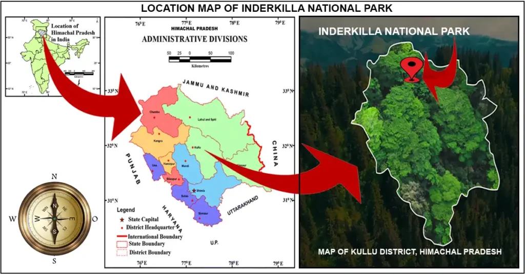
Inderkilla National Park Map and Boundary
Boundary Description of Inderkilla National Park Map including Eco-sensitive Zone of the Protected Area:
1. North: The boundary starts from Chhumuk with an approximate average 1300 m strip width up to the inner side of Inderkila Park.
Geo coordinates:
North: 77°17’15.548″ Latitude, 32°21’08.328″ Longitude
2. East: The boundary starts along the Hamta Pass, dividing the Lahoul Division and the Manali Forest Range.
Geo coordinates:
East: 77°20’07.848” Latitude, 32°19’07.491” Longitude
3. South: The boundary starts from the Chhika area of Jagatsukh-III Forest in the Naggar Range, extending with an approximate average width of a 1000-meter strip from the inner side of Tikru Tapri and Panju Tapri.
Geo coordinates:
South: 77°18’34.253” Latitude, 32°12’19.033” Longitude
4. West: The boundary starts from Bhrigu Lake, extending with an average width of a 900-meter strip from the ultimate boundary of Hamta Gahar C-III along Allain Nalla.
Geo coordinates:
West: 77°14’45.786” Longitude, 32°18’24.386” Latitude
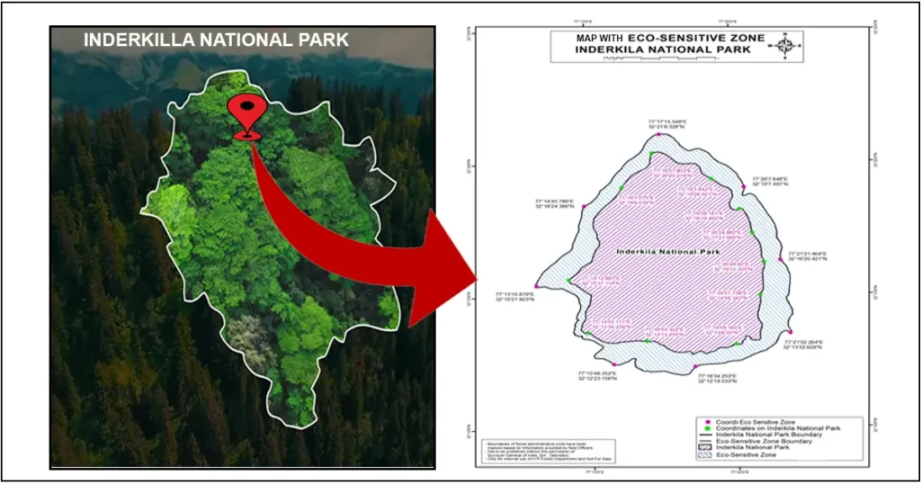 Inderkilla National Park Map with Eco-Sensitive Zone
Geography of Inderkilla National Park
1. Location: Situated in the Kullu valley the park boasts diverse terrain and ecosystems.
2. Vegetation: The park is adorned with a variety of vegetation, including mixed coniferous forests, moist temperate deciduous forests, subalpine fir forests, rolling alpine pastures, Kharsu oak forests, moist deodar forests, western mixed coniferous forests and ban oak forests. Juniper and rhododendron are prevalent throughout the area.
3. Biogeographic Zone: Inderkilla National Park falls within the Trans-Himalayan biogeographic zone characterized by its unique flora and fauna adapted to high-altitude environments.
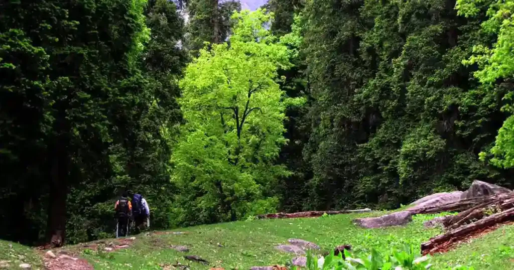
4. Terrain: The entire national park is covered with hilly terrain and dense woods, making it an ideal destination for hiking and trekking enthusiasts.
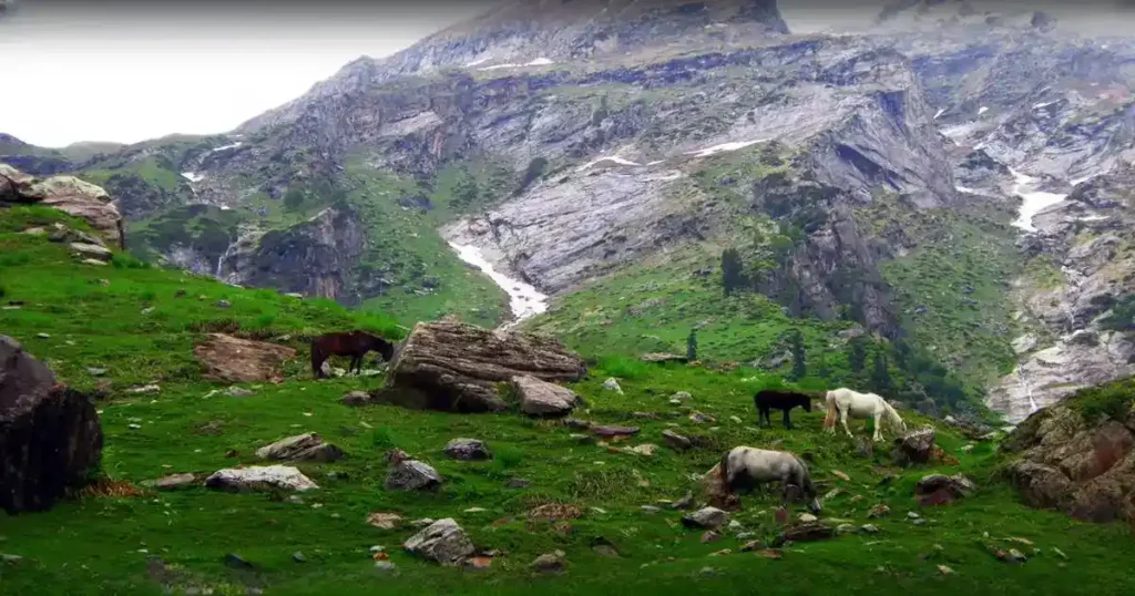
 Inderkilla National Park photos : maple forest
Inderkilla National Park Beas River
The Beas River flows through Inderkilla National Park, originating from Beas Kund, a glacial lake situated near the Rohtang Pass in the Himalayas. This river is a major source of water for the wildlife living in the park.
The Beas River is a significant river in northern India. It’s one of the five main rivers in Himachal Pradesh. This river flows through places like the Kullu Valley and Kangra Valley and it joins with the Satluj River in Punjab. The river helps the surrounding areas by providing water for plants and farms through irrigation practices related to agriculture.
The Beas River isn’t just important for water, but it also attracts tourists and adventurers. Its beauty and opportunities for rafting and fishing make it popular in Himachal Pradesh.
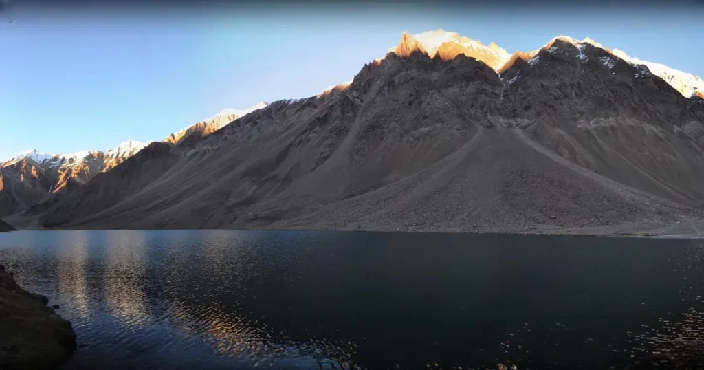 Inderkilla National Park photos : Chandratal Lake
Flora and Fauna Diversity of Inderkilla National Park
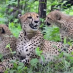
The Inderkilla National Park has a lot of different plants and animals, which are really important for nature. Some of the animals you might find there are leopards, bears, snow leopards, tahr, civets, martens, black bears, ibex, musk deer, monkeys, langurs, goral, jackals, jungle cats, flying squirrels, blue sheep, leopard cats, porcupines, monals, barking deer and more.
1. Rare and Endangered Species:
Moreover, the park is home to various rare, endangered and threatened flora and fauna species including Snow leopard, Himalayan Brown Bear, Himalayan Tahr, Black bear, Himalayan Ibex, Musk Deer, Himalayan Griffon, Rakhal, Bhojpatara, Maple, Gerardiana, Shingli mingli, Patish, Dhoop, Artemesia, Salam panja, Banaksha and others.
2. Rich Flora Diversity:
The park has a wide variety of plant species. Some of the notable ones reported from the Inderkilla Wildlife Sanctuary include Spruce, Fir, Kharsu, Burans, Rakhal, Khanor, Boxwood, Walnut, Bhojpatara, Prunus, Ash, Maple, Rubus, Kashmal, Guchhi and many more. These herbs, shrubs and trees contribute to the park’s rich biodiversity and ecological significance. The diverse vegetation supports a wide range of wildlife species and provides essential habitats for various flora and fauna to thrive within the sanctuary.
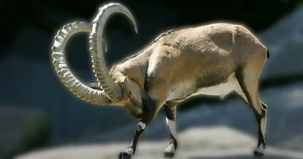 Inderkilla National Park photos : mountain goats
Explore Inderkilla National Park
When visiting Inderkilla National Park, visitors can spot different rare mammals including brown and black bears, deer, leopards, ibex and mountain goats.
The western mixed coniferous forest in the park is breathtaking. The pleasant temperature makes it a perfect place for tourists to enjoy. The narrow trails winding through the park allow tourists to see plants and animals in their natural habitat. The hilly terrain and dense woods make it ideal for hiking or trekking, attracting adventurers, nature lovers and wanderers alike.
Major Attractions
Visitors to Inderkilla National Park can enjoy various winter sports like camping, snowboarding, heli-skiing, trekking and birdwatching. It’s a paradise for bird and animal lovers. The park also connects the Kullu and remote Spiti valleys.
The Hampta Valley Trek, a world-famous trek is a must-try activity in the park. Mountaineering is also popular among visitors. Other unique activities include exploring the pristine wilderness and enjoying the crystal-clear waterfalls.
The park is home to various uncommon animals like Swamp Deers (Barasingha), tigers, ibex, deer and mountain goats. Visitors can see over 250 species of birds such as Kaleej and Monal.
The park’s rich biodiversity includes a coniferous forest with mixed deciduous trees. With its moist climate, the park has subalpine fir and kharshu along with rolling alpine pastures spanning from 2000 meters to 6221 meters in altitude.
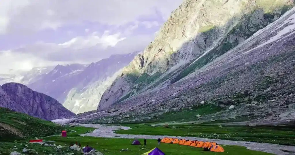
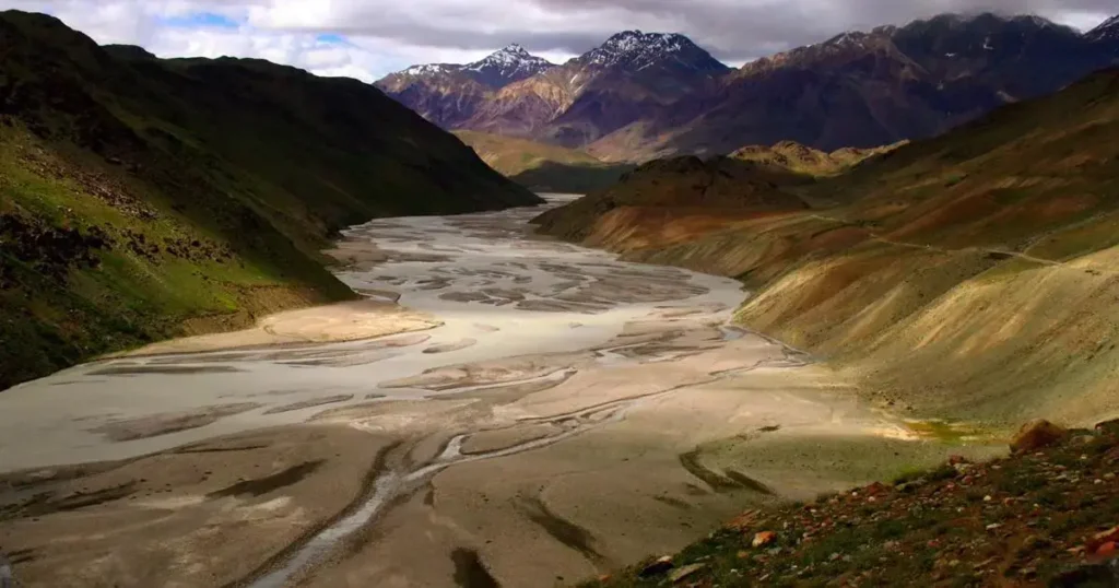
 Inderkilla National Park photos : Hampta Pass narrow valley
Hampta Valley Trek in Inderkilla National Park
Hampta Pass trek is not a very long trek. It’s a four- or five-day trek. But even in this short trek, you experience terrific scenery changes. First, the drive up to the Jobra start point is a climb out of Manali. There’s a road behind Manali that climbs up to nine thousand feet where one can look down at Manali. As you go up, there’s a tiny hamlet, but once you reach Jobra, aside from the beautiful drive, you’ll enter a maple forest.
Soon after the maple forest, which isn’t too big, the scenery changes immediately as you enter the open grasslands near Chika. Then, one goes up to the Jwara meadows where two valleys intersect at one place, putting you right in the middle of this grassy landscape with valleys from two sides.
Next, one reaches the camp at Balu Ka Ghera, which is just touching the snowline. Look how soon this is happening. Camping happens at all these places, so reaching the snowline and seeing the Hampta Pass right in front is possible, knowing where you’re going.
The whole Hampta Pass trek is through a very narrow valley, which isn’t often seen on treks. Because it’s so narrow, the mountains tower on either side. Lovely meadows are walked through with the river flowing right next to, crystal clear waters and the sound of the river.
Then, the scenery changes because this was the Kullu side of the tre, and once the Hampta Pass is hit and flipped over to the other side, it’s the Spiti side going from the lush green of Kullu to the desert of Spiti. Oh, what a contrast. Trekkers also have the bonus of the Chandratal trek if it’s accessible. Chandratal is a trek comparable to Pangong Lake in Ladakh, but it’s not as big. However, the colors, the setting, that desert landscape around it are amazing. Trekkers get to see and even go to Chandratal by doing the Hampta Pass trek.
Trekking the Hampta Pass is not so difficult and after completing the Hampta Pass trek, the scenery changes. Chandratal – come on, it’s a trek worth doing and not too difficult.
 Inderkilla National Park photos : Hampta Pass narrow valley
Best Time to Visit Inderkilla National Park
Tourists can visit Inderkilla National Park throughout the year, but the best time to visit is during October and November.
Entry Fee
Visiting Inderkilla National Park does not require any entry fee.
Opening Time of Inderkilla National Park
Inderkilla National Park is open daily from 10:00 am to 5:00 pm.
How to Reach Inderkilla National Park
By Air: Covering an extensive area of 104 square kilometers, Inderkilla National Park is located in the Kullu district. It is approximately 46.1 kilometers away from the Kullu Manali Airport.
By Railway: Joginder Nagar Railway Station, located 41 kilometres away, is the nearest railway station to Inderkilla National Park.
By Road: From Manali to Prini Village, it’s a distance of 12 kilometers via the Manali-Nagar State Highway. From Prini Village, visitors can trek to reach Inderkilla National Park starting from Sethan.
Where to stay
Visitors can stay at the Forest Rest House in Manali, or choose from many other excellent accommodation options available in the town of Manali. Starting from Manali, Inderkilla National Park is about 4 kilometres away.
Conclusion
Inderkilla National Park is located in Kullu, Himachal Pradesh, covering a large area of 104 square kilometers. The western mixed coniferous forest in the park has a pleasant temperature that tourists enjoy. Visitors can spot more than 250 bird species here, including Kaleej and Monal. The best time to visit is during October and November. Mountaineering is popular among visitors and there are many other unique activities like exploring the wilderness. The park is near the famous hill station, Manali and boasts many beautiful crystal-clear waterfalls.
FAQ
a) Why is Inderkilla National Park famous?
The Inderkilla National Park is famous for its specialty in recording more than 250 species of birds such as Kaleej and Monal. It is home to many endangered plants, animals, birds and insects including species such as black and brown bears, leopards and mountain goats. It also boasts a rich variety of medicinal plants.
b) Which river flows through Inderkilla National Park?
The Beas River flows through Inderkilla National Park, originating from Beas Kund, a glacial lake situated near the Rohtang Pass in the Himalayas. This river is a major source of water for the wildlife living in the park.
c) Inderkilla National Park is famous for which animal?
The Inderkilla National Park has a lot of different plants and animals, which are really important for nature. Some of the animals you might find there are leopards, bears, snow leopards, tahr, civets, martens, black bears, ibex, musk deer, monkeys, langurs, goral, jackals, jungle cats, flying squirrels, blue sheep, leopard cats, porcupines, monals, barking deer and more.
d) The inderkilla national park is located in which state?
Inderkilla national park is located in the Kullu district of Indian state of Himachal Pradesh. It was established in 2010 covering an area of 104 square kilometres (40 sq mi).
e) The relevance of Inderkilla National Park in UPSC examinations.
Covering an area of 104 sq. km, Inderkilla National Park was established in 2010. It is located in the Kullu district of Indian state of Himachal Pradesh. On January 17, 2018, the Ministry of Environment, Forest and Climate Change designated an area around the Inderkila National Park, extending from 469 meters to 2.125 kilometers as the Inderkila National Park Eco-sensitive Zone (referred to as the Eco-sensitive Zone) covering an area of 47.2 square kilometers.
You May Also Like
- Murlen National Park
- Phawngpui National Park
- Nameri National Park
- Raimona National Park
- Dibru Saikhowa National Park
6 thoughts on “Inderkilla National Park”