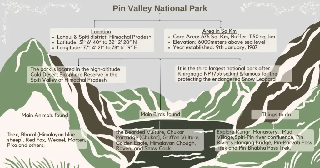
Pin Valley National Park is located in the Lahaul and Spiti district of Himachal Pradesh in North India. It was notified as a National Park covering 675 square kilometres on 9th January, 1987 through Government of Himachal Pradesh Notification No. Ft-(B) F (7)-31/86 dated 09-01-87. Moreover, on 11th March 2016, the Government of India expanded its protected area by adding 1150 square kilometers as an Eco-Sensitive Zone around the park. The Park is in the high-altitude Cold Desert Biosphere Reserve in the Spiti Valley of Himachal Pradesh.
The Cold Desert Biosphere Reserve, situated in the Western Himalayas within Himachal Pradesh, North India, was established as a biosphere reserve in August 2009. It encompasses Pin Valley National Park, Kibber Wildlife Sanctuary, Chandra Taal, and Sarchu.
Due to its location in the rain shadow of the Himalayas, the Cold Desert Biosphere Reserve is shielded from the effects of the summer monsoons. As a result, Pin Valley National Park also remains unaffected by these rainy seasons.
Pin Valley National Park Map and Boundary
The Pin Valley National Park comprises a core area boundary spanning 675 sq. km and an Eco-Sensitive Zone (Buffer Zone) covering an additional 1150 sq. km. Geographical coordinates: 31° 6’ 40″ to 32° 2’ 20″ N Latitude and 77° 4’ 21″ to 78° 6’ 19″ E Longitude.
A.) Core Area Boundary 675 sq. km.
1. North:
The north boundary of Pin Valley National Park starts at the highest peak of the district boundary of Himachal Pradesh between the Kullu and Lahoul-Spiti districts. It then follows the Hundungma ridge to the top of the Ratang River at a height of 5800 meters. Next, it continues along the ridge dividing the watersheds of Khaminger Khad and Kidul Cho from the Ratang River, ending at the top of Kidul Cho at a height of 5835 meters.
2. East:
From Kidul Cho’s peak, the boundary runs upstream along the Parahio River to Larang La, 5370 meters high. Then, it follows Larang La Khad downstream to where it meets the Pin River, tracing upstream to Tari Khango’s peak at 4865 meters, where it intersects the Kinnaur and Lahaul Spiti district boundary.
3. South:
From Tari Khango, the southern boundary of Pin Valley National Park follows the district boundary of Kinnaur and Kullu at Shakrang Khango, which stands at a height of 5100 meters.
4. West:
From Shakrang Khango, the park’s western boundary follows the district boundary of Kullu and Lahaul, and Spiti district through Pin Parvati passes up to Barashigri glacier at a height of 6632 meters.
 Pin Valley National Park photos: View from MIkkim village
B.) Eco-Sensitive Zone (Buffer Zone) Boundary1150 sq. km.
The Eco-Sensitive Zone (Buffer Zone) of Pin Valley National Park covers an area of 1150 square kilometers, with a boundary extending up to 45.82 kilometers.
- The southern boundary of the Eco-Sensitive Zone (Buffer Zone) of the National Park is contiguous with other protected areas such as Lippa Asrang Wildlife Sanctuary and Rupi-Bhawa Wildlife Sanctuary.
- The western boundary adjoins the Great Himalayan National Park and Khirganga National Park.
- To the north, it borders the Kibber Wildlife Sanctuary.
There are approximately 17 villages located within the periphery of the park, including Mud, Telling, Sagnam, Khar, Kungari, Bharr, Gulling, Tangti Yongma, Tangti Gongma, Cheuth, Kaa, Chhidang, and Mikkim. Sagnam is the largest village in Pin Valley National Park.
In Pin Valley, there are 17 summer settlements with farming inside the park. People live in these settlements during the summer. Most locals in Pin Valley are Buddhist. Kungri village has a famous Gompa situated in the buffer zone of the park. The dances performed by the monks there, called Chham and Buchen dances, are famous in the valley.
The map of Pin Valley National Park, along with the Core Area and Eco-sensitive Zone boundaries, as well as latitude and longitude details, is attached.
 Pin Valley National Park Map
Geography of Pin Valley National Park
Pin Valley National Park, located in the Indian Himalayas, is part of the Cold Desert Biosphere Reserve, along with Kibber Wildlife Sanctuary. Spanning 7,770 sq. km, this reserve is characterized by its cold desert biome. In this arid region, rainfall is scarce, mainly occurring as snow or fog, particularly at higher elevations and latitudes.
a. Valley’s Characteristics
Pin Valley, like Khirganga and much of Himachal Pradesh, is rugged with immense relief and sparse vegetation. Even at its lowest point, it’s 3,500 meters above sea level.
b. River Confluence
Pin Valley National Park is where the Spiti River meets one of its main tributaries, the Pin. The Spiti, 225 kilometers long, is vital for the valley, dividing the Lahaul-Spiti district. The Kunzum Pass, 4,551 meters high, links the two areas. Most of Spiti’s settlements are along the Spiti River.
c. Geological Features:
The Pin River, cutting through the valley, shapes dramatic landscapes with steep slopes and deep gorges. High-altitude conditions create unique geomorphology, like stark mountain faces and rock formations.
d. The Spiti River: Glacier-Dependent Lifeline:
The Spiti River starts from glaciers around Kunzum and Chandratal Wildlife Sanctuary, flowing southeast. Its catchment area is over 6,300 square kilometers. Since it’s on the leeward side of the Himalayas, it doesn’t get summer monsoons like most of India. Instead, it relies entirely on glacier meltwater. Climate change is shrinking glaciers, posing a growing risk to communities and wildlife dependent on the river.
e. Sheer Cliffs and Aeolian Erosion:
The valley’s steep terrain results in sheer cliffs, formed by tectonic activity and differential erosion, where softer rocks erode faster than harder ones, creating dramatic vertical drops.
f. Glacial Influence:
Glacial moraines scatter throughout the park, and frost weathering contributes to rocky terrain. Freeze-thaw cycles lead to angular rock fragments and scree slopes.
g. Rainfall and Alluvial Deposits
Sporadic heavy rainfall forms alluvial fans and cones at gorge mouths, depositing sediment and debris on the valley floor.
 Pin Valley National Park photos: Valley of Five Colors
Climate of Pin Valley National Park
The weather in Pin Valley National Park is typically cold and dry due to its location in a high-elevation and cold desert biosphere reserve. During winter, from late October to March, the weather is very cold and snowy. Temperatures can drop as low as -20°C to -5°C (-4°F to 23°F), and heavy snowfall sometimes blocks the roads, making it difficult to access or leave the valley.
Summers are short, lasting from June to September, and are slightly warmer. This warmer weather, with average temperatures ranging from about 5°C to 15°C (41°F to 59°F), is beneficial for the plants and animals in the valley. During this time, as the snow melts, the valley transforms with lush greenery and wildflowers blooming.
In between, during the shoulder months, the weather can change a lot. Temperatures can range from 0°C to 10°C (32°F to 50°F). During these times, the weather is unpredictable, with the chance of experiencing either sudden snowfall or warmer days.
 Pin Valley National Park photos: Cultivation during July-August
Flora and Fauna of Pin Valley National Park
1. Flora:
The Pin Valley is known for having two main types of landscapes: alpine pastures, which are high-altitude grasslands where animals graze, and dry alpine scrub forests, which are forests with low-growing shrubs and trees adapted to the harsh mountain conditions. In the valley bottoms, plants like Salix spp. and Myricaria spp. naturally grow. Snow leopards rely on Myricaria shrubs for food during the winter. Over 400 plant species have been found in this area.
The Pin Valley is also known for its medicinal plants, which have been used in traditional medicine for a long time. Some examples are Ephedra gerardiana, Aconitum heterophyllum, and Dactylorhiza hatagirea (Himalayan marsh orchid).
Junipers are coniferous trees often found on rocky slopes and can withstand harsh, dry conditions. Locals often used them in traditional medicines and rituals.
Willow trees are found growing along streams and rivers in the park. They adapted to the moist conditions and helped stop the ground from washing away.
Sea buckthorn has bright orange berries and is valued for its nutritional and medicinal properties.
The Himalayan Blue Poppy is a blue flower that blooms in the park’s alpine meadows during the summer months.
Edelweiss is a famous mountain flower that also grows in the Himalayas and Pin Valley. It has white, star-shaped flowers.
 Pin Valley National Park photos: Blue Poppy
2. Fauna
There are more than 20 species of animals and birds found in the Pin Valley National Park.
a.) Animals: One notable species for which the park is famous for its protection is the endangered Snow Leopard, with an estimated population of about twelve. Other animals include Ibex, Bharal (Himalayan blue sheep), Red Fox, Weasel, Marten, Pika and others.
b.) Birds: The park is also home to various bird species. Among them are the Bearded Vulture, Chukar Partridge (Chukor), Griffon Vulture, Golden Eagle, Himalayan Chough, Raven, and Snow Cock.
 Pin Valley National Park photos: Animals
Things to do in Pin Valley National Park
1. Exploring Kungri Monastery: A Glimpse into Ancient Nyingmapa Buddhism:
There are several monasteries to visit in Pin Valley, but Kungri Monastery, also called Kungri Gompa or Pin Gompa, is the most famous. After crossing Attargo Bridge, drive 16 kilometers to Gulling Village. Then, take the uphill road on the right to reach Kungri Monastery.
a. Historical Background:
Built in 1330, Kungri Monastery is believed to be the second oldest in Spiti Valley, after Tabo Monastery. It’s the only monastery following Nyingmapa Buddhism. “Kungri” means “snow mountain” in Tibetan, as the monastery is nestled below snowy peaks. Legend says Guru Padmasambhava, or the second Buddha, founded it. When visiting, explore both the old and new monastery buildings.
b. Exploring the Old Monastery:
The entrance to the old monastery is through a narrow door, leading to a central hall. Unlike other richly decorated monasteries, there aren’t many wall paintings or clay images here. Manuscripts line the walls, and there’s a large prayer wheel in a side room. Inside, there’s a statue of Demchhog and Phangmo, representing Lord Shiva and Parvati. Some murals are damaged, possibly due to the Sikh invasion of Spiti in 1841 or earlier raids by Ghulam Khan.
c. The New Monastery:
Next to the old building is the new monastery, featuring a central image of Tandupa, a form of Buddha, adorned with precious stones. The image was brought in a glass case from Shimla, carried by humans due to road conditions. While the frescos on the walls appear newer, scholars believe the carved wooden pieces are ancient.
 Pin Valley National Park photos: Kungri Monastery
2. Explore Mud Village: The last settlement on the Indo-Tibet Border:
Mud village is the last settlement on the Indian side of the Indo-Tibet border. It has several homestays and guesthouses. With a population of about 210, Mud Village is a typical starting point for treks in the park and marks the end point of both the Pin Parvati and Pin Bhaba treks on the Spiti side.
Mud became famous among geologists in the 1860s because of the extensive array of visible strata known as the Muth Formation, which stretches over 300 meters high. This weather-resistant layer is composed of white quartz arenite, containing various ripple marks and burrows, and dates back to around 420 million years ago.
As you arrive, a big Buddhist Stupa welcomes you to Mud village. The Spiti landscape changes with lots of greenery and flowers around the village. The powerful Pin River flows beside it, making the whole area lush with green and snowy mountains in the background. Strong winds move clouds, creating shadows in certain spots. Mud Village is as beautiful and colorful as the surrounding valleys. It feels like a paradise with its peaceful silence and isolation.
 Pin Valley National Park photos: Mud Village
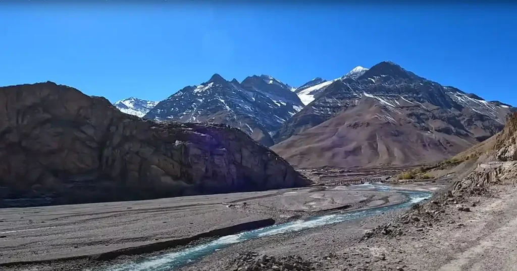
3. View Spiti-Pin river confluence from Dhankar village:
The Pin River originating from the southwestern part of Spiti Valley is the lifeline of the Pin Valley National Park. It cuts through the valley before joining the Spiti River just after the Attargo bridge near Dhankar. The Spiti River originates from the Kunzum range of the Himalayas. Dhankar village is the best place to view the confluence of the Spiti and Pin rivers. But you can also stop by after the Attargo bridge to take some great photos of the joining point.
4. Explore Pin River’s Hanging Bridge near Mikkim Village:
There is a hanging bridge laden with colorful Tibetan flags over the Pin River near Mikkim village in Pin Valley National Park. There is also a small stream of the Pin River to the other side. The sensation of crossing the shaky bridge and feeling the icy water is truly exhilarating. The vast stretch of the Pin River bank, surrounded by towering brown mountains, made it one of the most picturesque locations of the Spiti Valley journey.
5. Explore the Pin-Parvati Pass Trek:
The Pin-Parvati Pass trek starts from Mud Village in Pin Valley National Park and is one of the most challenging high-altitude treks in Himachal Pradesh. This mountainous range separates the Pin Valley from Parvati Valley, where Khirganga National Park is situated. The Pin-Parvati Pass reaches an altitude of 17,500 feet, covering 100 kilometers.
To trek the Pin-Parvati Pass, prior experience of at least two high-altitude treks is required. It takes at least six days for most trekkers to complete the trek in one direction, covering around 80 km with 4,200 meters of elevation gain.
6. Explore the Pin-Bhaba Pass Trek:
Pin Bhaba Pass is one of the most beautiful and scenic trails. It is also known as the Shepherd’s Trail.
The Mud village serves as a base camp for trekkers heading towards the Pin-Bhaba Pass. This trek extends over a distance of about 50 kilometers and typically takes 7-8 days to complete. The trek reaches an altitude of 15,900 feet at the Bhabha Pass, linking the Pin Valley to the Bhabha Valley. The route leads from the cold, dry, deserts of Spiti and the Pin Valley to the lush Bhaba Valley.
This trek requires prior experience and good physical fitness due to its difficulty. Unlike longer treks such as Parvati, this one is shorter and has less elevation gain. Various companies provide trekking packages from places like Spiti, Kullu, and Shimla.
 Pin Valley National Park photos: Pin Bhaba Pass Top (Altitude-16105 ft)
The best time to visit Pin Valley National Park
The best time to visit Pin Valley National Park is during April, May, November, and early December for animal sightings, and July & August for those interested in plants and geology. During the winter season (December to March) heavy snowfall occurs in the valley hence it is very difficult and dangerous to approach the park.
How to reach Pin Valley National Park
There are two main routes to reach Pin Valley National Park.
Route No. 1: This route is a Summer Route open from July to October.
- Travel from Shimla to Chandigarh to Kullu by air or bus (272 km).
- Then, take a bus from Kullu to Kaza via Manali, Rohtang Pass (3978 m), and Kunzam Pass (4551 m) (260 km).
- Next, take a bus or jeep from Kaza to Mikkim (32 km).
- Finally, walk from Mikkim to the Park Area (10 km).
Route No. 2: (Winter Route)
- Take a bus from Shimla to Tapri.
- From Tapri, take a bus to Kaza (park HQ).
- Then, follow the same path as Route No. 1, taking a bus 32 km from Kaza to Mikkim, and then walking to the Park Area, which is 10 km away.
The nearest railway station is in Shimla and the nearest airport is in Bhuntar, Kullu.
Where to Stay
There are several homestays and guesthouses at Mud village which is the last settlement on the Indian side of the Indo-Tibet border. It is the starting point for treks in both the Pin Parvati pass and Pin Bhaba treks on the Spiti side.
Conclusion
Nestled in the Cold Desert Biosphere Reserve in the Spiti Valley of Himachal Pradesh, Pin Valley National Park is a pristine and untouched destination ideal for travelers who desire to immerse themselves in the tranquillity and beauty of natural surroundings. While it’s possible to visit Pin Valley as a day trip from Kaza, consider spending a night in Mud Village instead. Mud Village offers basic homestay accommodations where guests stay with residents. This experience allows for a deep understanding of their culture, traditions, and challenges.
FAQ
a.) What is the Pin Valley National Park famous for?
Pin Valley National Park is famous for the protection of the Snow Leopard, with an estimated population of about twelve of these endangered animals. Other animals found in Pin Valley National Park include Ibex, Bharal (Himalayan blue sheep), Red Fox, Weasel, Marten, Pika, and various others.
b.) Is Pin Valley worth visiting?
Pin Valley National Park is definitely worth visiting. There are plenty of things to do and see, such as exploring Mud Village, the last settlement on the Indian side of the Indo-Tibet border. It’s as beautiful and colorful as the surrounding valleys, giving off a paradise-like vibe with its peaceful silence and isolation. You can also visit Kungri Monastery and experience trekking adventures like the Pin-Parvati Pass trek or the Pin-Bhabha Pass trek
c.) The relevance of Pin Valley National Park UPSC examinations:
Pin Valley National Park is located in the Lahaul and Spiti district of Himachal Pradesh in North India. It was notified as a National Park covering 675 square kilometers on 9th January 1987. The park is part of Cold Desert Biosphere Reserve and is famous for its protection of the endangered species Snow Leopard.
d.) Which river is from Pin Valley National Park?
The Pin River originating from the southwestern part of Spiti Valley is the lifeline of the Pin Valley National Park. It cuts through the valley before joining the Spiti River just after the Attargo bridge near Dhankar Village.
You May Also Like
- Khirganga National Park
- Inderkilla National Park
- Murlen National Park
- Phawngpui National Park
- Nameri National Park
- Raimona National Park

6 thoughts on “Pin Valley National Park”