One of the most heavily inhabited nature reserves in Himachal Pradesh, India, is Nargu Wildlife Sanctuary, located on the banks of the Uhl River in Chuhar Valley in the Mandi district. Nargu was established in 1962 and notified as Nargu Wildlife Sanctuary in 1999, covering an area of 278.00 sq km. Later, on 29th November 2013, due to rationalization, the area of Nargu Wildlife Sanctuary was reduced to 132.3731 sq km.
This high-altitude sanctuary contains narrow valleys with steep to precipitous slopes and rocky cliffs. It is divided into the beats of Panjaund, Pungent Samalang, Khaban, Badaun, Sarglwah, and Rulang. The blooming pink rhododendrons in the area make for a breathtaking view during the summer months. The Barot village is connected to Kulu via a trekking trail that is a major gateway to the sanctuary.
The highest point in the sanctuary is the majestic Nargu Top, from which a splendid view of Himachal’s major districts, namely Kangra, Mandi, and Kullu, is visible. The top, which acts as a crossing point for shepherds trekking, these routes also offers scenic views of the horizon.
In terms of hydrology, the umpteen nalas (drains), springs, curds, and streams in the area that drain into the Beas River ensure the survival of numerous plant and animal species. Hurang Narayan Temple and Dehnasar Lake are some of the spellbinding attractions.

History of Nargu Wildlife Sanctuary
The history of Nargu Wildlife Sanctuary is representative of the formation and subsequent modification of its boundaries for better conservation. What follows is a brief timeline of events, from its declaration in 1962 to rationalization of the boundaries, which has resulted in its present area
- 1962: Nargu Wildlife Sanctuary was originally established.
- 23rd October 1999: Initially notified as Nargu Wildlife Sanctuary covering an area of 278.00 sq. km under Notification No. FFE-B-F(6)-16/99.
- 7th May 2010: Intention notification issued under Section 18 of the Wildlife (Protection) Act, 1972, proposing rationalization of boundaries (IA No. 139/2010 in Writ Petition Civil No. 337 of 1995).
- 28th July 2010: Intention notification issued to include an additional 40.00 sq. km to the existing area of 278.00 sq. km.
- 5th August 2011: The Supreme Court directs the State Government to follow procedures under Sections 18 to 26A and 35 of the Wildlife (Protection) Act, 1972, before issuing final notifications (Supreme Court order dated 05/08/2011).
- 1st February 2013: The Supreme Court permits the State Government to issue final notifications under Sections 26A, 35(4), and 36A regarding the rationalization of boundaries (Supreme Court order dated 01/02/2013).
- After Rationalization: An additional 63.413 sq. km is included and 209.4285 sq. km is excluded as per recommendations of Collector, Kullu.
- Current Status: The total area of 132.3731 sq. km (278.3886 sq. km + 63.413 sq. km – 209.4285 sq. km) constitutes Nargu Wildlife Sanctuary after rationalization (No. FFF-b-F(6)-16/1999-Nargu dated 29th November 2013).
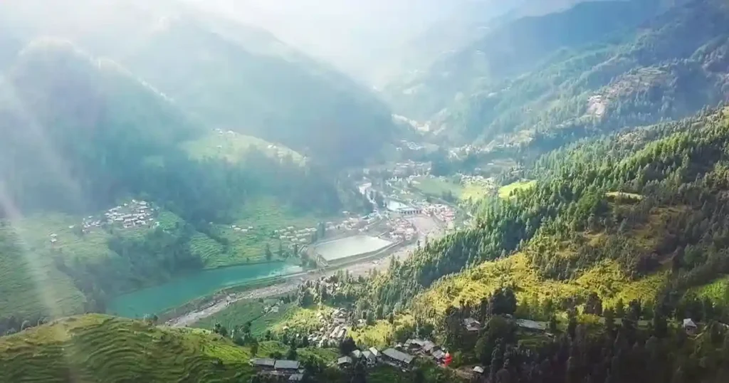 Nargu Wildlife Sanctuary Photos: Barot Village
Nargu Wildlife Sanctuary Boundary and Map
The whole boundary of Nargu Wildlife Sanctuary is surrounded by the Forest Divisions and Wildlife Sanctuaries. The sanctuary is situated within the jurisdiction of the Kullu Forest Division, although it is partially located in the Mandi district. The boundary description of the sanctuary is as follows:
1. NORTH: The northern boundary of Nargu Wildlife Sanctuary starts from Chakrola Thach in Deodhar P.F. and moves along the ridge boundary of Deodhar P.F. up to Shirar-ra-Tibba. Then the boundary moves along the southwest boundary of Dhouladhar Wildlife Sanctuary along the upper side with the district boundary up to Garalatinu Galu.
2. EAST: From near Garalatinu Galu, the eastern boundary of Nargu Wildlife Sanctuary moves downward, following the boundaries of Gordug P.F. and Chebanag P.F. to Kelakarao Thach, then to Malidug Thach. It continues along the boundary of Sapurnal P.F. up to Karaun Forest Rest House. From Karaun FRH, it follows the boundary directly to the confluence of Paha Nala, reaching the boundary of Khokhan Wildlife Sanctuary up to Kandi Galu, and then moves along this boundary to the common boundary of Kullu and Mandi districts.
3. SOUTH: The southern boundary of sanctuary starts from Kandi Galu and moves to the northern side of Kandi village and then descends along with a small stream to join Dulchi Nalla. It runs along the northern side of Matiyana village and follows up to Baraun Nalla along the contour of 1600-meters.
4. WEST: Starting from Baraun Nalla, the boundary follows the eastern boundaries of Baraun, Shanar, Seri, Bharyanu, and Brari villages. Descending with a small stream to Shera ra Nalla, it ascends alongside the northern boundaries of the Gartanu and Gharaun villages.
It ascends eastward to the 2600-meter contour, passing near Bhadwani and Kartang villages, and through Aolgwar, Daint, and Damwan villages.
Following the contours of Tegar and Terang villages, it ascends to 2740 meters, then traces paths near Lthran and Jhakwan Ghar Nalla. It follows Banjasgarh village’s path and southern boundary at the 1720-meter contour, then ascends along the district boundary of Mandi and Kangra to Chakrola Thach.
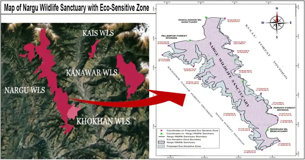 Nargu Wildlife Sanctuary Map with Boundary and Eco-Sensitive Zone
Geography and Climate of Nargu Wildlife Sanctuary
1. Geography:
Basically, the geography of Nargu Wildlife Sanctuary is mountainous, characterized by undulating low hills in the west and steep to precipitous mountains in the north and east. The large number of high ridges, cliffs, deep gorges, and narrow valleys adds variety to the features of the sanctuary. Abundant nalas, springs, creeks, and streams help in the hydrology of the area and feed into the Beas River to maintain the survival chances of a variety of plant and animal species.
The geographical coordinates of the sanctuary are: latitude 31°46′N to 32°05′N and longitude 76°50′E to 77°04′E with an altitudinal range of 970 to 4000 meters above mean sea level.
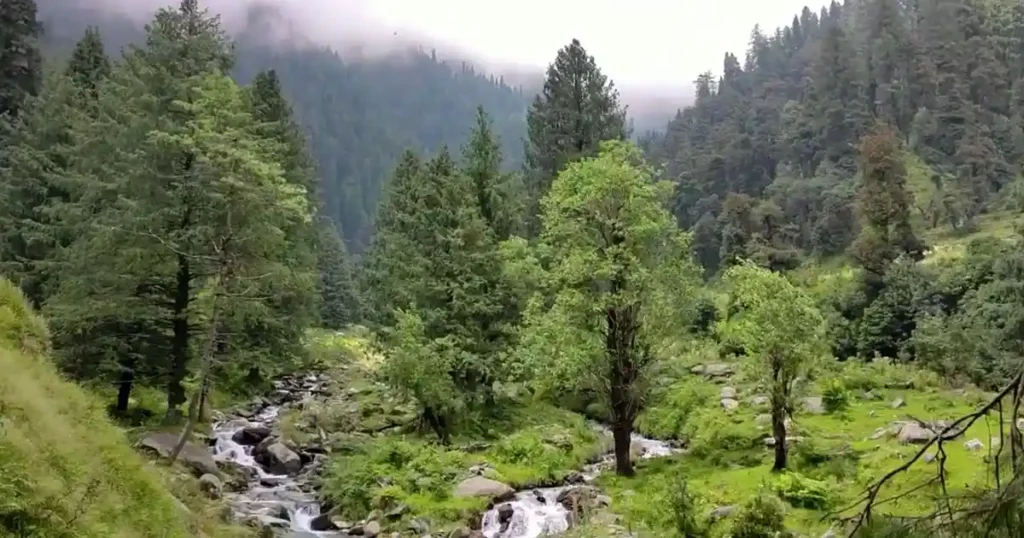
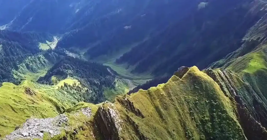
 Nargu Wildlife Sanctuary Photos: Chuhar Valley
2. Climate:
The climate of Nargu Wildlife Sanctuary is characterized by sub-tropical, temperate, sub-alpine, and alpine conditions, encompassing summer (mid-April to mid-June), rainy (mid-June to September), and winter (October to March) seasons. Temperatures range from −10°C to 35°C, and the average annual precipitation is 1,400 mm. The sanctuary receives precipitation in the form of both snowfall and rainfall. Approximately 80% of the precipitation is from the southwest monsoon, with the remainder coming from western disturbances.
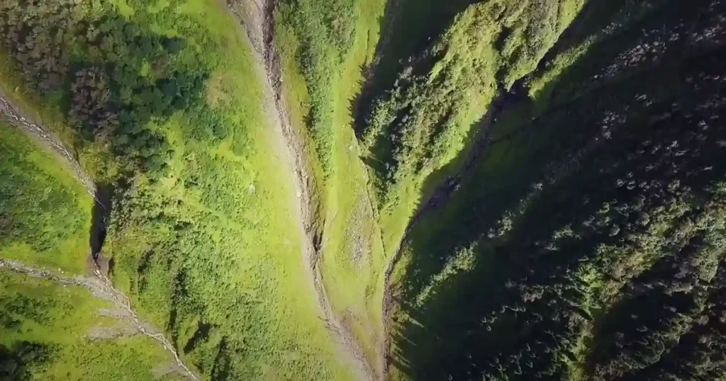 Nargu Wildlife Sanctuary Photos: Umpteen nalas (drains)
Flora and Fauna of Nargu Wildlife Sanctuary
1. Flora:
The forest of Nargu Wildlife Sanctuary consists of Moist Deodar, Moist Temperate Deciduous, Kharsu Oak, Sub-tropical Chir Pine, Western Mixed Coniferous, and Western Himalaya Sub-alpine Fir forests. Key tree species such as deodar, fir, kharsu (Quercus semicarpifolia), prunus, maple, juglans, rhododendron, Celtis, fig, and ban (Quercus leucutrichophora) are found here.
In Nargu Wildlife Sanctuary, a total of 45 plant species, along with their botanical name, family, vernacular name, and habitat, belonging to 28 different families, were identified. Most of these species (16) were herbs and shrubs, followed by trees (6), climbers (5), and ferns (2).
Leaves of plants were the most commonly used for medicinal preparations. Rosaceae is the largest number of plant species.
Local people used different parts of the plant to cure several diseases including snakebites, coughs, colds, and some other infectious diseases. The people of Nargu Wildlife Sanctuary continue to depend on wild medicinal plants for their healthcare needs. Therefore, effective conservation planning is essential to protect these valuable plant species in the region.
 Nargu Wildlife Sanctuary Photos: Medicinal Plants
2. Fauna:
The main species found in Nargu Wildlife Sanctuary include threatened species such as the common leopard, ghoral, barking deer, black bear, jackal, Himalayan civet, Himalayan yellow-throated marten, and flying squirrel. The sanctuary is the habitat of four out of seven pheasant species found in Himachal Pradesh. It has been recognized as an important bird area for the Himalayan monal, which is an endemic vulnerable species restricted to the Himalayan region of India. Other notable bird species include the white-crested kalij, chukor, black and grey partridge. Common reptiles found in the sanctuary include snakes and monitor lizards.
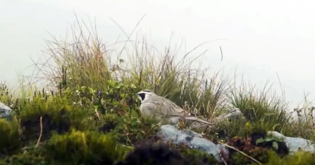 Nargu Wildlife Sanctuary Photos: Birds
Things to do at Nargu Wildlife Sanctuary
Nargu Wildlife Sanctuary is a hidden paradise in the Chuhar Valley of Mandi and Kullu districts. Trekking through this sanctuary is very relaxing and enjoyable. At the higher altitudes, there are some dense patches in the sanctuary and it’s very calm and natural. You can have fresh trout fish here and the camping site alongside the Uhl River.
Day 1: Trek from Panjaund Village to Dehnasar Lake
Comparatively, the trek through Panjaund village to Dehnasar Lake is longer than the trek from Phallan village. From Barot to Garaman village, there is a 20 km journey via Thaltukhod Village. The actual trekking journey begins from the Garaman village, which is surrounded by beautiful green hills. As you know, Himachal is called Dev Bhoomi, and here you will get small temples on every road.
1. Journey to Panjaund Village:
After a long trek, you will arrive at Panjaund village. There is a temple of Fungni Mataji in this village .In Panjaund, old Himalayan-style houses made of wood, stone, and mud can be seen.
2. Trek through Panjaund Village:
Panjaund village is the last village on the Dehnasar Lake trek. Nettles grow on both sides of the road, so one needs to be very careful because if touched, they cause a lot of burning sensation. While trekking, you will see many small, beautiful streams. Along the way, you will see the people of Panjaund Village grazing their animals. The view alongside Panjaund Nala (stream) is very beautiful. The river flowing through the lush green high mountains and forests looks very beautiful.
3. Crossing the Last Stream:
After some distance, you will have to cross the last stream. There is no bridge here, so one has to cross with caution. After crossing the stream, the trek continues for about two to three hours without any water sources, so be sure to fill your water bottles here.
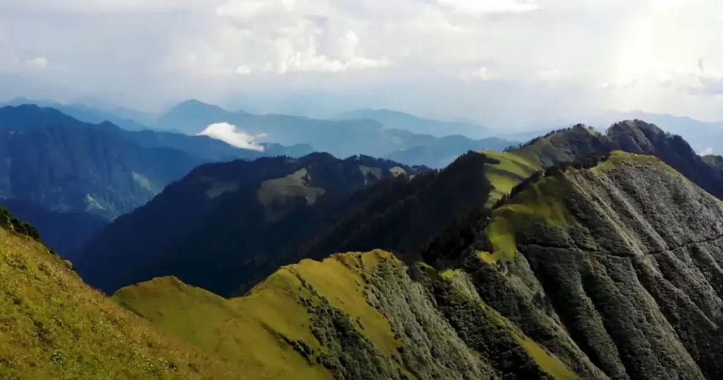
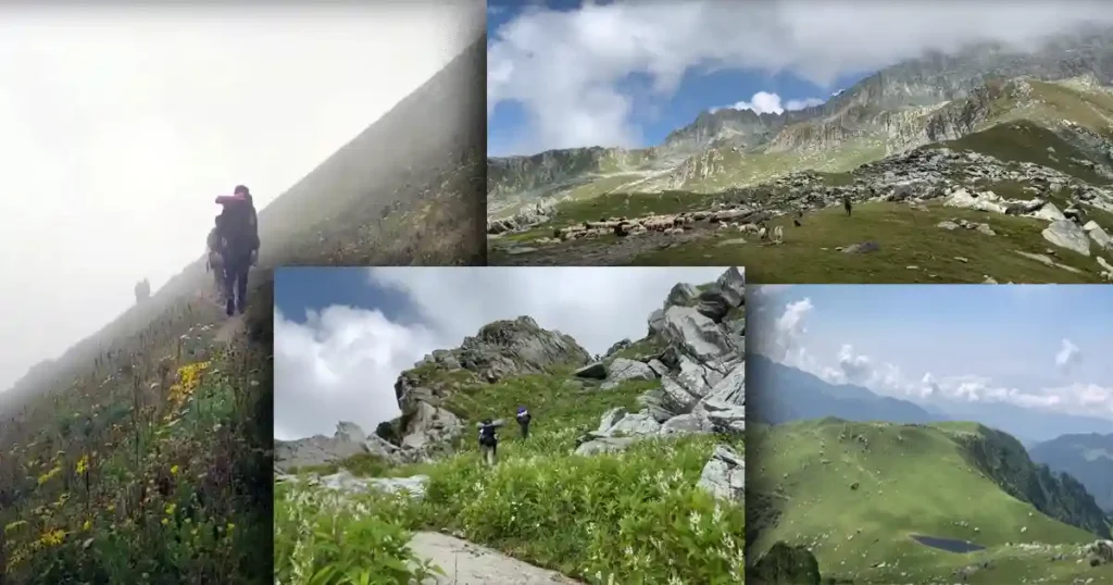 Nargu Wildlife Sanctuary Photos: Trekking View
4. Journey through the Dense Forest:
After crossing the water stream, you will see a dense forest. The villagers have made a wide and high road from here, but the climb is very steep, so you will need to rest at many places.
After trekking for almost two hours, it may seem like the trek will never end. The hills and forests have become more prominent, and you can see some animals grazing in the area. After going some distance further, the dense forest ends, and flowers and small plants begin to grow. Smokey weather can occur in the mountains at any time, so if you are unfamiliar, stay with your group and do not go far; otherwise, you may lose your way.
5. Reaching Fungni Mata Lake:
After walking through green trees for a while, the path ahead passes through big rocks, and you will finally reach Fungni Mata Lake amidst the beautiful green mountains. It is very beautiful and quiet. You will need to camp here for the night, and the next day, you will trek to Dehnasar Lake.
 Nargu Wildlife Sanctuary Photos: Panjaund Nala
Day 2: Trek to Dehnasar Lake
The next day, you will continue your trekking journey through lush green flowers and big mountains. On the way, you will see some more beautiful lakes. Amidst the trek, you will find Sari Lake in the mountains, which is breathtakingly and naturally beautiful. Every year, the roads get damaged due to glaciers, and you have to find your way.
Every year, many people from Kull, Barot, Mandi, and surrounding areas come to take a holy dip in Dehnasar Lake. According to the Hindu calendar, taking a holy bath on the 20th of Bhadrapada month, which falls on the 4th or 5th of September, is considered very auspicious. Dehnasar Lake is also dedicated to Lord Shiva, like Manimahesh Lake and Mansarovar Lake.
1. About Dehnasar Lake:
Dehnasar Lake is located in the Chhota Bangal region of Kangra district in Himachal Pradesh. The lake’s height from its base is 4280 meters above sea level. It is more approachable from Mandi and Kullu District, although it is in Kangra District. It is a glacier lake formed by the melting of the surrounding glaciers. It is situated beside rocky cliffs at the top of the mountain. During winters, it lies frozen under a thick coat of snow, and due to the high altitude, blizzards and hailstorms are common in the area.
The water of this lake is snow water and is very cold, hence it is tough to take a bath, but devotees still take a bath in the icy cold water here with full faith and devotion. There are many small temples made of stones near Dehnasar Lake, most of which are dedicated to Lord Shiva. On the day of the holy bath, priests from nearby villages come here to offer prayers.
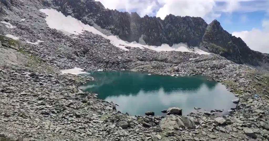 Nargu Wildlife Sanctuary Photos: Dehnasar Lake
2. Return Journey:
On the journey back to Barot Village from Dehnasar Lake, you can take a new path through Phallan village. This is a shorter trek, and from Phallan village, you can get a taxi to Barot.
Best Time to Visit
The best month to visit Nargu Wildlife Sanctuary is April to June and August to October. During these months, the weather is perfect for visiting, trekking, good chances for wildlife spotting, photography, and enjoying the beauty of nature of the sanctuary.
How to reach there
The Nargu Wildlife Sanctuary is located about 55 km from Mandi and 30 km from Joginder Nagar in the district of Mandi and Kullu of Himachal Pradesh. A major gateway to the sanctuary is the village of Barog, which is connected to Kullu via a trekking trail.
• By Air: The nearest airport is Kullu (100 km away from the sanctuary)
• By Rail: Barot Station located within the sanctuary
• By Road: Shimla to Mandi – 160 km. There is a road from Mandi to Jogindernagar going close to the western boundary of the sanctuary.
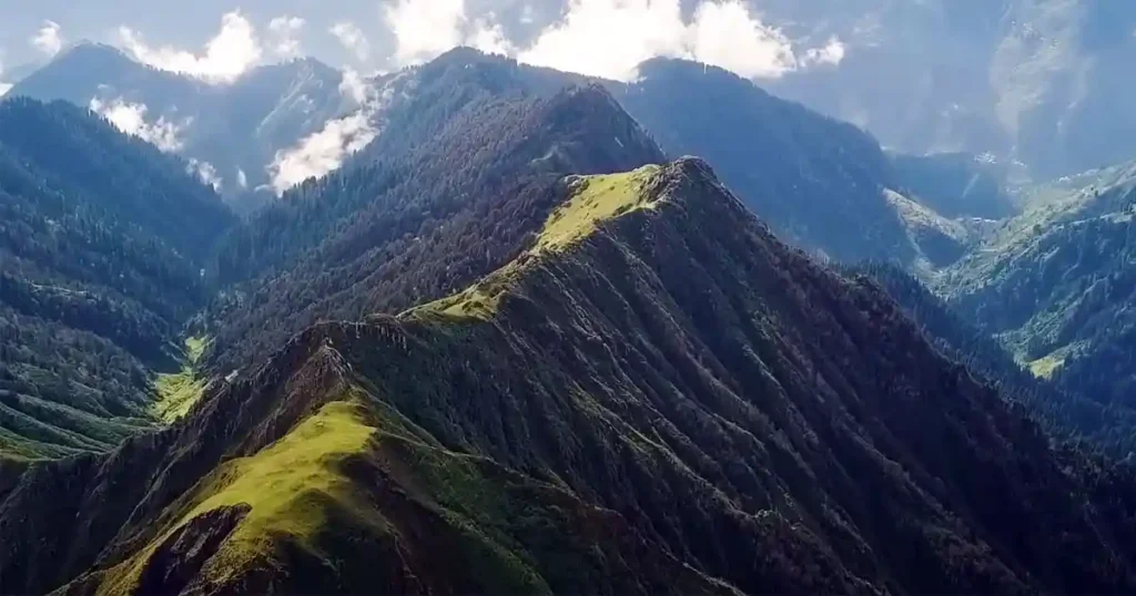
 Nargu Wildlife Sanctuary Photos: View from Panjaund Hill Top
Where to Stay
Travelers visiting this sanctuary can avail themselves of accommodation facilities in the forest rest houses located at Thaltukhod, Ropa, Sibadhwani, and Kathog.
Conclusion
Covering 132.37 sq. km., Nargu Wildlife Sanctuary is located on the banks of the Uhl River in the Mandi district of Himachal Pradesh, India. This high-altitude sanctuary contains narrow valleys with steep to precipitous slopes and rocky cliffs. From the majestic Nargu Top, it is a splendid view of Himachal’s major districts, namely Kangra, Mandi, and Kullu. A total of 45 plant species were identified belonging to 28 different species. The local people of Nargu Wildlife Sanctuary continue using medical plants found in the sanctuary to treat cuts, skin diseases, snakebites, coughs, colds, and infections.
Therefore, it is very important to pay more attention to research on these traditional medicinal plant species to improve human health, particularly in geographical areas that lack access to good healthcare facilities. Effective conservation planning is essential to protect these valuable plant species found in Nargu Wildlife Sanctuary.
FAQ
a. Which is the largest wildlife sanctuary in Himachal Pradesh?
Spread over a vast 2220 sq. km, Kibber Wildlife Sanctuary is the largest and the only cold desert sanctuary in all of India is located in the Spiti Valley of Himachal Pradesh. Kibber, also known as Kibber Khas, is the last village in Spiti on the traditional trade route to Ladakh and Tibet, from which the sanctuary derived its name.
b. How many Wildlife Sanctuaries are there in Himachal Pradesh in 2024?
There are 5 National Parks (a total of 2407.28 sq. km), 26 Wildlife Sanctuaries (a total 5964.9731 sq.km.) and 3 Conservation Reserves (a total 19.17 sq.km) in Himachal Pradesh.
c. What animals are in Mandi Himachal Pradesh?
Mandi, Himachal Pradesh, is rich in wildlife due to its varied habitats. Animals found here include Himalayan Black Bears, Leopards, Barking Deer, Gorals, Himalayan Tahrs, and Serows. You can also find Monal Pheasants, Western Tragopans, Red Foxes, Langurs, Porcupines, and Himalayan Musk Deer in this region.
You May Also Like
- Kanawar Wildlife Sanctuary
- Simbalbara National Park
- Pin Valley National Park
- Khirganga National Park
- Inderkilla National Park
References
1 thought on “Nargu Wildlife Sanctuary”