On 15th August 2024, during the 78th Independence Day speech, the Chief Minister of Assam, Dr. Himanta Biswa Sarma, announced the recognition of the Chirang-Ripu Reserve Forest, located on the Indo-Bhutan border in the Chirang and Kokrajhar districts, as Sikhna Jwhwlao National Park. Subsequently, in the Assam Cabinet meeting held on 16th February 2025, the government officially approved the decision, and the Governor of Assam issued an official notification declaring Sikhna Jwhwlao National Park, covering an area of 316.29 sq. km, vide E. No.544255/214, exercising the powers conferred under sub-sections (1) and (2) of Section 35 of the Wildlife (Protection) Act, 1972.
This new national park is situated in the Bodoland Territorial Region (BTR) in Assam, India, adjacent to the eastern part of Raimona National Park, across the Saralbhanga River (locally known as Swrmanga).
The Sikhna Jwhwlao National Park formed comprising Haltugaon Forest Division, Jharbari forest range in Kokrajhar district and Runikhata Range in Chirang district is the 08 (eighth) national park in Assam and the 03 (third) in BTR after Manas National Park and Raimona National Park. The Chief Minister’s announcement was met with widespread enthusiasm among forest workers, nature lovers and the general public.
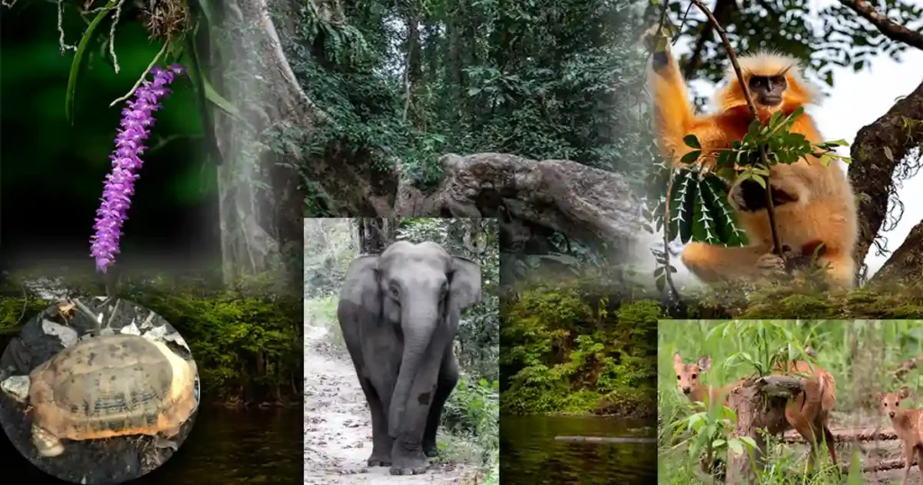
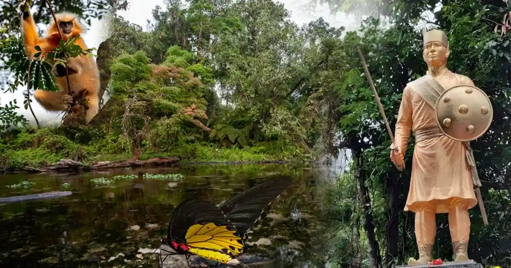
The golden langur, the mascot of BTR, is also found in the Sikhna Jwhwlao National Park.
The park is 222 km from Guwahati, 45 km from Bongaigaon, and 40 km from Kokrajhar, the capital of the Bodoland Territorial Region (BTR).
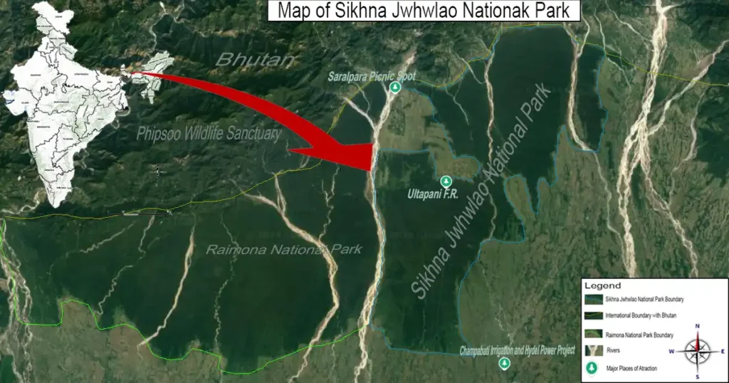
Sikhna Jwhwlao National Park: Named after the legendary Bodo hero, Sikhna Jwhwlao
The park is named after Sikhna Jwhwlao, a legendary Bodo hero known as Jaolia Dewan, who ruled the region and fought during the Duwar War between Bhutan and the East India Company, which took place around 1864-66, against British forces. His capital, Sikhnajhar (Chiknajhar-Nou Nwgwr), was located at Ultapani reserve forest, near Sarbhang, an Indo-Bhutan border town that is now within Sikhna Jwhwlao National Park. The area where relics remain is considered a sacred abode of deities and spirits, and the Bodo people perform Bhathau Kherai puja, a traditional Bodo worship, there every year.
Major Places to visit within the park
Ultapani, where the Ultapani River flows from west to east, is a hotspot for butterflies. A 2009 study by zoologist Kushal Choudhury of Kokrajhar Science College along a 25 km stretch from Bishmuri FV to Ultapani FV through Sikhna Jwhwlao National Park recorded 7,431 butterfly deaths across 81 species over one year (2007-2008). Along these roads, one might encounter elephant herds, golden langurs, and birds such as the Great Indian Hornbill and Red Junglefowl, etc.
Saralpara Saralpara, a popular picnic destination that attracts visitors from all over the state to enjoy the scenic beauty of waterfalls, creeks, mountains, and refreshing cold baths during summer, is located at the western-north corner fringe of Sikhna Jwhwlao National Park, in the foothills of the Bhutan international border.
Establishment of Sikhna Jwhwlao National Park
The Chirang-Ripu Reserve Forest, which was notified as the Chirang-Ripu Elephant Reserve and designated as a MIKE Site (Monitoring the Illegal Killing of Elephants) for its historical elephant habitats on 06/03/2003 vide No. FRW-44/2002/47 by the Govt. of Assam’s Environment and Forests Department, under the guidelines provided by the Project Elephant Division, MoEF&CC, Govt. of India, covering an area of 2,600 sq. km along the Indo-Bhutan border. It forms a contiguous habitat, bordered by Buxa Tiger Reserve (part of the Eastern Dooars Elephant Reserve in West Bengal) to the west and Phipsoo Wildlife Sanctuary in Bhutan to the north.
The Chirang-Ripu Elephant Reserve includes the Kachugaon Forest Division and Haltugaon Forest Division in the Kokrajhar district, the Aie Valley Forest Division in the Chirang district, as well as the Darrang Forest Division, Mangaldoi Wildlife Forest Division, and North Kamrup Forest Divisions, along with Manas National Park.
It is worth mentioning that in the past few years, the Chirang-Ripu Elephant Reserve has been destroyed by illegal deforestation and conversion of the forest land into agriculture. As a result, elephant-human conflict has intensified in the area in recent years.
Every year, many people are killed and their homes damaged by wild elephant attacks. On April 7th, 2024, a wild bison, which came out from the presently recognized Sikhna Jwhwlao National Park, rampaged through adjacent forest villages in Chirang Reserve Forest, affecting areas in both Kokrajhar and Chirang districts of Assam. In two separate incidents, the bison attacked and grievously injured five people.
The first attack occurred in Islakata village, Chirang district, where a 40-year-old was injured. Villagers attempted to chase the bison, which then crossed the Champabati River into Kokrajhar district. There, it attacked four more people in Haldibari village, leaving one in critical condition. Later, forest department officials handled the situation and chased the wild bison back into the jungle.
There are many wildlife sanctuaries in the country and the forest department and the BTC administration have been trying to protect the reserve from deforestation but these moves have failed every time due to the interests of some political parties.
As a result, valuable trees were cut down and destroyed with the sponsorship of some forest mafias. In parallel, they established one village after another and converted the reserved forests into farmland.
Therefore, the BTC Forest Department Executive Member, Ranjit Basumatary, led by Chief Executive Member of the BTC Administration, Pramod Boro has taken up a plan to upgrade it to a national park to protect the almost destroyed protected forest area.
Later, a survey was conducted and a proposal was sent in late February 2024 to the Government of Assam to recognize it as a National Park covering an area of 321.90 sq km. The Chief Minister of Assam, on 5th August 2024, during the 78th Independence Day speech announced the recognition of 321.90 sq. km. of Chirang-Ripu Sanctuary as the Sikhna Jwhwlao National Park to conserve the endangered forest area.
The Chief Minister’s announcement is considered a groundbreaking step in protecting the endangered forests in the region as the nearby Raimana Forest in Kokrajhar district after its recognition as a National Park on June 9th, 2021, the almost destroyed Raimana Forest has taken on a new form.
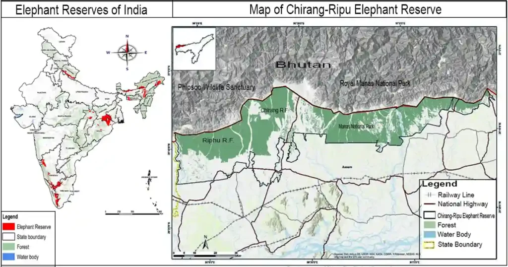
Sikhna Jwhwlao National Park Boundary
The boundary description of Sikhna Jwhwlao National Park also called Chiknajhar National Park is as follows:
1. North:
The northern boundary of Sikhna Jwhwlao National Park is located near a market area called Saralpara Bazar and several small villages within the Saralpara forest area. These villages are named Saralpara Dakshin (South), Saralpara Paschim (West), Saralpara Purba (East), Saralpara Uttar (North), and more.
The park shares an international border with the Sarpang District of Bhutan, extending to a town called Gelephu in Bhutan. There is a road entry point at Saralpara that connects India with Bhutan, leading to the district headquarters in Sarpang and further east along the Sarpang-Gelephu-Trongsa highway to Gelephu town. This road provides access from India into Bhutan.
2. East:
The eastern boundary of the park, which falls within the Chirang district of BTR, includes several fringe forest villages such as Deosri FV, Santipur FV, Khungring FV, and Bhur FV, extending up to the Laoti Mini Hydro Electric Power Project. The Champabati River, originating from the Bhutan hills, serves as a natural boundary dividing both the Kokrajhar and Chirang districts.
3. West:
The western boundary of Sikhna Jwhwlao National Park shares a transboundary with the eastern boundary of Raimona National Park. The Saralbhanga River, known as Sarbhang Chu River in Bhutan, flows from Bhutan through both Raimona and Sikhna Jwhwlao National Parks, forming the transboundary along the western edge of Chiknajhar Jwhwlao and the eastern edge of Raimona.
4. South:
The southern boundary of Sikhna Jwhwlao National Park is marked by several forest villages, including Purana Ouguri, Kashiguri FV, Khalashi, Genduguri, Jharbari Bazar, Bodopur, Dimapur, Mohendrapur FV, Badranpur FV, Gyanipur, Digli Bajar, Mohanpur FV, and Bashbari FV. There is National Highway 27 (NH27), which is about 7 kilometers away from the park. This highway serves as a significant road that is relatively close to the park’s southern edge.
Geography and Climate of Sikhna Jwhwlao National Park
1. Geography:
The area of Sikhna Jwhwlao National Park falls within the typical Bhabar belt, intersected by numerous watercourses. The ground gently slopes from north to south, with elevations ranging from 85 to 240 meters above mean sea level. The major rivers flowing through the park are Saralbhanga, Samukha, Champabati, Bhur, Laopani, and Dholpani, all originate from the Bhutan hills and serve as significant tributaries to the Brahmaputra River. The Bhur, Laopani, and Dholpani Rivers are three sub-tributaries of Champabati River.
Mashbhander is the only perennial lake located inside the Ultapani Forest Block. There are numerous rivulets and streams, most of which remain dry during the dry season. The soil across much of the Bhabar area is dry sandy loam, overlaid on a bed of pebbles, with only a very thin humus layer. Surface stones are fairly common.
2.Tectonic Features of Sikhna Jwhwlao National Park:
The Ultapani, Lalbheti, and Saralbhanga blocks within Sikhna Jwhwlao National Park each reveal significant tectonic activity. The Ultapani block features an oval uplift and a northern scarp 10 to 25 meters high, showing past seismic events with river blockages and 16,000-year-old clay deposits. The Lalbheti block has a striking 35 to 50-meter-high north-facing scarp and fault folds, reflecting multiple recent earthquakes. The Saralbhanga block includes a 6 to 10-meter-high scarp and similar clay deposits. Together, these blocks illustrate Sikhna Jwhwlao National Park’s tectonic history and seismic activity through its uplifted terrains, fault scarps, and sedimentary deposits.
3. Climate:
The climate of Sikhna Jwhwlao National Park is classified as a moist tropical monsoon with temperatures ranging from 7°C to 34°C and rainfall varying from 15mm in winter to 1162mm during the monsoon season.
Biodiversity of Sikhna Jwhwlao National Park
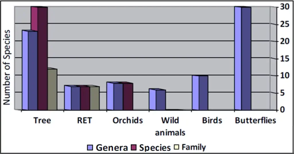
Sikhna Jwhwlao National Park Photos: Graphical representation of biodiversity status of Ultapani Forest Reserveis famous for Saralpara, a popular picnic spot, and Ultapani FV, a biodiversity hotspot renowned for its rich butterfly population.
According to a survey conducted by Jintu Sarma of Guwahati College in 2014, a total number of 30 tree species (23 genera, 12 families), 7 Rare, Endangered, and Threatened species (7 genera, 7 families), 8 orchid species (8 genera, Orchidaceous family), 6 wild animals, 10 birds, and 30 butterfly species are documented in the Ultapani Forest Reserve.
1.Flora:
Due to its unique geographical location and geology, the park encompasses as many as twelve different types and sub-types of forests, including very moist Sal forests, sub-Himalayan high alluvial semi-evergreen forests, moist mixed deciduous forests, riparian fringing forests, savannah forests, orchids, and Khair-Sissoo forests, as well as wide riverbeds, as classified by Champion and Seth. These different types of environments available in the park help support a wide array of wildlife.
2.Fauna:
Maharaja Niprendra Narayan Bhup Bahadur of Cooch Behar, in his hunting journal “Thirty-Seven Years of Big Game Shooting”, notes that in March 1900, shot three pigs, five bears, 11 tigers, one bison, two sambar, 11 leopards, one rhino, three water buffaloes, three hog deer, and three pigs in the forests along the Saralbhanga River near the Bhutan foothills.
These forests, located in the biodiversity-rich foothills, now form part of Sikhna Jwhwlao National Park in BTR, Assam, within the Eastern Himalaya Biodiversity Hotspot. The area continues to support a wide range of wildlife due to the transboundary movement of species such as elephants, golden langurs, tigers, leopards, spotted deer, hog deer, wild pigs, monitor lizards, tortoises, porcupines, wild buffaloes, bison, cobras, pythons, insects, birds, fishes, butterflies, and other wildlife.
These species move through the northern Phibsoo Wildlife Sanctuary in Bhutan, West Bengal, and Rainmona National Park, and enter Sikhna Jwhwlao National Park via the Saralbhanga River.
3. Elephant Reserve:
Known for its historical elephant habitats, the government of Assam declared Chirang-Ripu Elephant Reserve a MIKE site on March 6, 2003, covering an area of 2,600 sq. km. The newly established Sikhna Jwhwlao National Park, along with Raimona National Park and Manas National Park, plays a crucial role in the transboundary movement of elephants and other wildlife through northern India.
The North Brahmaputra Elephant Range of India (Project Elephant, 2007), located in the foothills of the Eastern Himalayas, comprises three elephant reserves: Kameng, Sonitpur, and Chirang-Ripu. Kameng and Sonitpur Elephant Reserves connect with Bhutan, and together with Chirang-Ripu, they extend through the Duar belt and the Tarai tract. This range supports approximately 3,250 elephants, with the Chirang-Ripu Elephant Reserve in Bodoland Territorial Region (BTR) hosting 658 elephants as of Project Elephant, 2005.
Recently, large-scale deforestation in this reserve, excluding Manas National Park, has intensified human-elephant conflicts. These legendary elephant herds are now in peril due to habitat fragmentation. A 2011 study by Aaranyak, a conservation NGO, found that elephant distribution in the landscape has been severely fragmented and reduced due to anthropogenic activities.
Hopefully, the new declaration of Sikhna Jwhwlao National Park will help mitigate these issues.
4. Golden Langur Population and Conservation Efforts:
The golden langur (Trachypithecus geei), regarded as the mascot of the Bodoland Territorial Region (BTR) and associated with the mythological Sugriva from the Ramayana, has been the subject of a comprehensive survey conducted across its distribution range in India. Completed in February-March 2024, this survey involved organizations such as the Primate Research Centre NE India (PRCNE), Forest Department, Bodoland Territorial Council, SACON, and Conservation Himalayas.
The survey revealed a total population of 7,396 golden langurs in India, divided into two major sub-populations. The northern extended population, including the Manas Biosphere Reserve, is estimated at 5,566 langurs in 534 groups, with 23 lone males. Within this area, Raimona National Park hosts approximately 2,847 individuals.
In the southern fragmented areas, there are about 1,830 langurs in 173 groups, with 8 lone males. Significant populations in the south are found in Chakrashila WLS of Kokrajhar district and Kakoijana RF of Bongaigaon district.
In Chirang Reserve Forest, now part of Sikhna Jwhwlao National Park, the golden langur population is notable, with approximately 2,000 individuals. The recent designation of Chirang RF into Sikhna Jwhwlao National Park will protect nearly 90% of the golden langur habitat in India. This strategic move is expected to enhance conservation efforts and safeguard the golden langur population and their habitats.
5. Birds:
Sikhna Jwhwlao National Park, with its geographic and ecological similarities to Raimona National Park, is home to a rich diversity of avian fauna. While no formal avian survey has been conducted in Sikhna Jwhwlao National Park yet, the transboundary migration of birds between this park and Raimona suggests that similar species are found here as well.
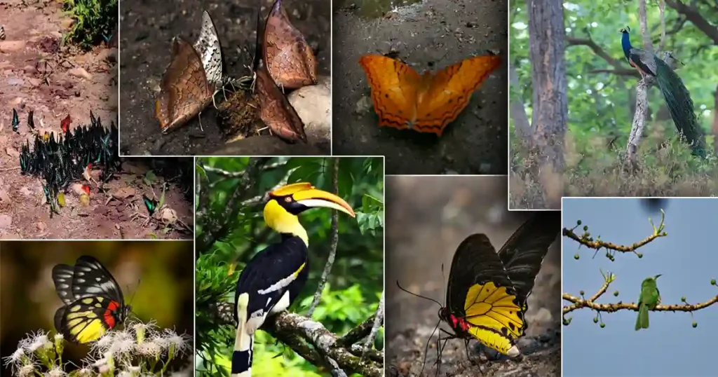
Given the resemblance in habitat, it is reasonable to expect that Sikhna Jwhwlao National Park also supports a substantial number of avian species, potentially including the 227 species recorded in Raimona. This could include notable species such as the Great Indian hornbill, Wreathed hornbill, Rufous-necked hornbill, and various species of raptors like those from the orders Accipitriformes, Falconiformes, and Strigiformes.
Furthermore, due to the suitable grassland and forest habitats, Sikhna Jwhwlao National Park hosts species such as the Swamp francolin, Bengal florican, and the critically endangered White-bellied heron, similar to those in Raimona. Notably, the Red Junglefowl is present in large numbers in this park.
6. Butterflies:
Ultapani reserve forest within the Sikhna Jwhwlao National Park is the “Haven of Butterfly” and is home to rare butterfly species such as the Yellow-crested Spangle (Papilio elephenor Doubleday) and Moores cupid (Shijimia moorei), documented by Kushal Choudhury, zoologist and assistant professor at Kokrajhar Science College, in 2009.
Moores cupid is a tiny butterfly, an extremely rare butterfly under the Lycaenidae family mainly found in southern China and Japan and its flight is very fast compared to its size. Several decades ago, this species was reported in Meghalaya’s Khasi Hills but hasn’t been seen elsewhere in India since. It is listed in Schedule I of the Wildlife (Protection) Act, 1972, and categorized as Critically Endangered by the IUCN.
The yellow-crested spangle, which was sighted after a gap of 100 years, was documented by Kushal Choudhury and identified and confirmed by Krushnamegh Kunte, a post-doctoral research fellow at the FAS Center for Systems Biology, Harvard University.
Mashbhander, where many fish are found, is the only perennial lake located inside the Ultapani Forest Block. During the dry season, it is one of the only places where butterflies can always be seen mud-puddling.
In 2009, zoologist Kushal Choudhury and fellow researchers conducted a study along a 25 km stretch from Bishmuri FV to Ultapani FV within Sikhna Jwhwlao National Park, documenting 7,431 butterfly fatalities across 81 species over one year (2007-2008). The higher mortality rates observed in the Nymphalidae, Pieridae, and Papilionidae families, highlight the impact of vehicular traffic on butterfly populations.
Mortality rates peaked during the monsoon season, primarily due to mud-puddling behavior, where butterflies gather on wet soil to extract nutrients. To mitigate this, researchers developed artificial mud-puddling sites 15 meters away from the main road, using natural attractants like cattle urine and carcasses. These sites successfully lured butterflies away from the road, reducing road-kill incidents.
The new protected status of these forests as part of Sikhna Jwhwlao National Park could help regulate vehicular traffic, potentially reducing butterfly mortality.
Places to visit in Sikhna Jwhwlao National Park
Presently, there are no safaris, opening hours, or entry fees required for visiting Sikhna Jwhwlao National Park, as the park’s primary objective is to protect against deforestation and conserve wildlife. However, visitors can explore certain areas using their vehicles, such as the Saralpara Picnic Spot, Ultapani Forest Village, and the Champamati Irrigation Project (Major), where the Laoti Mini Hydro Electric Power Project is located.
A road passes through Sikhna Jwhwlao National Park via NH 27 and the Bismuri-Saralpara-Sarbhong Road, providing access to Ultapani Forest Village, Saralpara Picnic Spot, and Sarbhang in Bhutan. Along this route, one may encounter elephant herds, deer, golden langurs, birds, butterflies, and other wildlife. Elephant herds are frequently spotted during the morning and evening hours when visiting these areas.
1. Saralpara Picnic Spot:
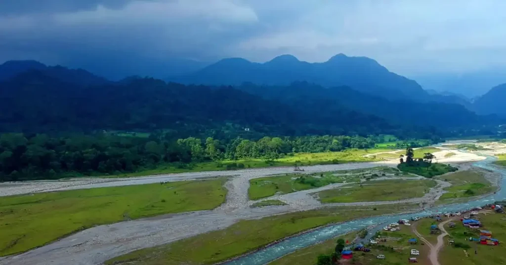
Saralpara is a popular picnic spot located at the northwesternmost boundary of Sikhna Jwhwlao National Park, in the foothills of the Bhutan international border. It lies on the bank of the Saralbhanga River, which flows from Bhutan, where it is known as the Sarbhang Chu River, in the Kokrajhar district of BTR, Assam, India.
It is a picturesque location situated amidst tall mountains, with splendid natural beauty, waterfalls, hills, valleys, and rivulets, including the Saralbhanga River, running through the valley. A gentle breeze blows throughout the day, making it a perfect spot for spending time in nature.
The entry fee for Saralpara Picnic Spot is ₹100 for bikes and ₹200 for cars. No entry fee is required for individuals.
The place is more accessible from Kokrajhar town via NH 117A and Bismuri-Saralpara-Sarbhong Road, a 62.9 km drive that takes about 2 hours and 12 minutes, or from Bongaigaon town via NH 27 and Bismuri-Saralpara-Sarbhong Road, a 66.4 km drive that takes about 1 hour and 59 minutes.
The place is mainly inhabited by Nepali, Bodo, Rabha, and Adivasi people. There is also Indo-Bhutan Friendship Market in Saralpara where you can buy local products. If you are planning to visit Saralpara, having your vehicle is highly recommended, as the area is remote and cut off from outside communication. Once in Saralpara, you will experience the feel of being in a Bhutanese village, with a small Bhutanese temple, prayer flags, and numerous large betel nut gardens.
2. Ultapani FR: Where Sikhna Jwhwlao’s Relics Remain and Butterflies Haven
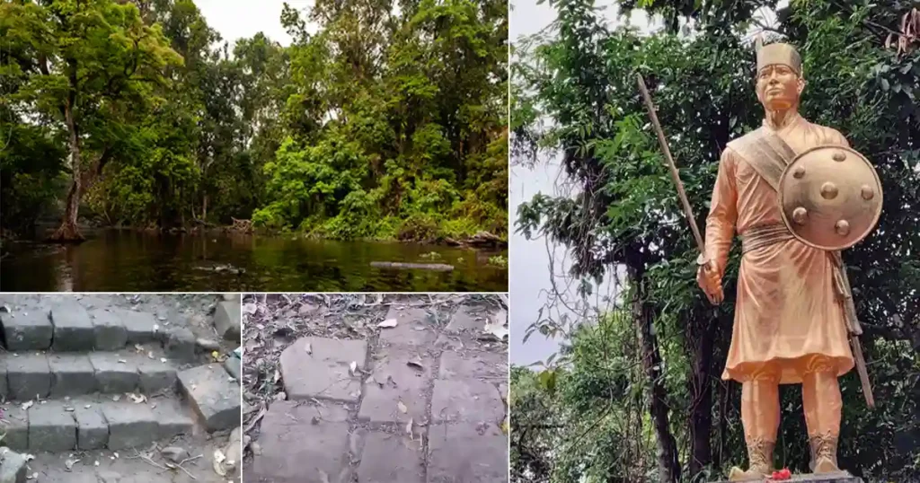
Mashbhandar, a natural fishpond lake located near Ultapani FV in the Ultapani Forest Reserve, is a perennial water source. Water flows from Mashbhandar Lake in two directions: from west to east, forming the Ultapani River, also known as the “Reverse River” due to its west-to-east flow, and from east to west, forming the Samokha, also called the Alaikhungri River. The Ultapani Forest Village is named after the Ultapani River.
The Ultapani Forest Reserve, located within the geographical coordinates 26°68.18″ N to 26°81.18″ N and 90°24.44″ E to 90°41.90″ E, is known as the “Haven of Butterflies.” Visitors can spot the broken relics of Sikhna Jwhwlao, the Statue of Sikhna Jwhwlao, and the Ultapani River, where stones are still said to be red. Jaolia Dewan, who fought against the British to protect his village from their demands for taxes, was captured and killed by British forces while drinking water from the Alaikhungri River. The river turned red with his blood, and today, the stones in the river are still said to be red as a mark of his sacrifice.
The Ultapani Forest Reserve also features Majbhander Lake, the only perennial lake, a variety of mud-puddling butterflies, Golden Langur, Hornbills, Peacock, medicinal plants, and timber-yielding plants.
Ultapani FV is about 30 km from Bishmuri and approximately 50 km from Kokrajhar town.
3. Off-Road Adventure: Bike Ride from Khalashi to Saralpara along the Bank of the Saralbhanga River
Riding a bike off-road from Khalashi village to Saralpara through the western boundary of Sikhna Jwhwlao National Park, along with Raimona National Park, following the bank of the Saralbhanga River, locally known as the Swrmanga River, is a wonderful experience. During the journey, visitors will encounter the beautiful natural scenery, forests, orchids, Lalbati Hajw (Hill), and wildlife such as elephants, deer, birds, butterflies, and the golden langur.
This trail, about 32 km long from Khalashi to Saralpara, is accessible only during the winter months from November to March
In 1906, there was a plan to build a 21-mile meter-gauge tramway from Kokrajhar to the Saralbhanga River. The idea was to provide sleepers (railroad ties) to Kokrajhar on the E.B. Railway at low costs, which would benefit the Forest Department. The Railway would also benefit by getting ballast from the Saralbhanga River, with only the cost of extraction. However, the proposed connection was never built.
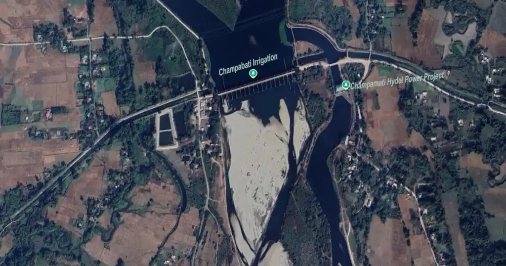
4. Champabati Irrigation and Champamati Hydel Power Project
The Champabati Irrigation Project is a 258.50m long barrage across River Champamati, a tributary of the Brahmaputra located in the southern part of the Chirang district, defining the boundary between Kokrajhar and Chirang districts. It is located on the southeasternmost boundary of Sikhna Jwhwlao National Park
It is popularly known as the Laoti picnic hotspot where, every New Year, large groups from different communities gather to celebrate with singing and dancing. Another notable attraction is the 4 MW Champamati Hydel Power Project, also known as the Laoti Mini Hydro Electric Power Project, which was inaugurated on January 12, 2010, and is worth visiting.
Geographically, the Champabati Irrigation Project area is located at 26°36′ N latitude and 90°22′ E longitude. It has a design flood discharge of 2,266.00 cumecs and a catchment area of 552.00 square kilometers.
Canal Network:
- Left Bank Main Canal: 14.36 km
- Left Bank Branches, Minors/Sub-minors: 127.33 km
- Right Bank Main Canal: 8.77 km
- Right Bank Branches, Minors/Sub-minors: 80.38 km
The districts that benefited from the project are Kokrajhar, Chirang, and Bongaigaon. The administrative approval for the project was granted by the state on July 26, 1980. Construction began in 1981, and the barrage was completed in 1995.
It is approximately 28 km from Kokrajhar Town and 30 km from Bongaigaon.
Conclusion
The announcement of the recognition of a total area of 321.90 sq. km of Chirang-Ripu Elephant Reserve as Sikhna Jwhwlao National Park, also called Chiknajhar National Park on August 15, 2024, during the 78th Independence Day speech by the Chief Minister of Assam is a step toward protecting the endangered forests in the region, as well as safeguarding wildlife species and recalling the historical highlights of Jaolia Dewan and a new tourist destination. It is hoped that, following the Chief Minister’s initiative, Sikhna Jwhwlao National Park will become like Raimona National Park and emerge as an ideal national park for wildlife, having been newly greened.
FAQ
Q: Chiknajhar National Park is located in which district?
A: Chiknajhar National Park is located in the Kokrajhar and Chirang districts of the Bodoland Territorial Region of Assam, India. The park, covering an area of 321.90 sq. km, is formed by combining the Haltugaon and Jharbari forest ranges in Kokrajhar district and the Runikhata Range in Chirang district.
Q: Chiknajhar National Park famous for?
A: Chiknajhar National Park is famous for the Ultapani Reserve Forest, known as the ‘Haven of Butterflies,’ which is home to rare butterfly species such as the Yellow-crested Spangle and Moore’s Cupid. The park is also renowned for Sikhna Jahar, located at Ultapani, and the Saralpara Picnic Spot. Wildlife such as the Golden Langur, Hornbill, Red Junglefowl, and herds of elephants are frequently spotted along Bishmuri-Diglibazar to Saralpara Road.
You May Also Like



1 thought on “Sikhna Jwhwlao National Park”